| 
|


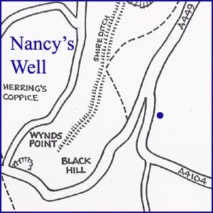
Nancy's or Mary's Well
NGR 76952 40674
Site Number: C62
By Bruce Osborne and Cora Weaver (C) 2012
Area 6. British Camp Area Springs and Wells
Malvern Hills, England
Description: a contained source with some occasional seepage from beneath a sycamore tree on the eastern side of the Welland Road.
Preamble - There are two wells in this locality, Ditchfords and Nancy's or Mary's Well. Both likely come from the same underground spring source but are dealt with separately; see locations 71 Ditchfords Well and 72 Mary or Nancy's Well.
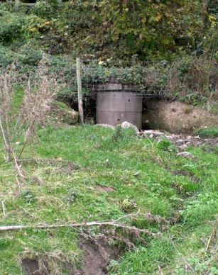
Nancy's Well was located near Ditchfords Well, on the east side of the Welland Road and the lower slopes of Black Hill. Water has flowed from Nancy's Spring within living memory but in recent years the water was contained and piped using large, perforated, concrete pipes laid vertically. Occasionally a wet area appears in the field near the sycamore tree at the roadside, the only visible indication of the water from Nancy's Well. It is possible that Nancy's Well and Ditchfords Well came from the same source and, as Little Malvern Priory is only about 200 metres away, both may have been the water supply for the Benedictine monks - amongst whom was William Langland, the author of the medieval poem Piers Plowman.
The water was renowned for its curative properties. Wetted linen applied to ulcerous cases was found to be particularly beneficial and is just one example of hydrotherapy predating the introduction of this technique to Malvern by Dr Wilson. In his "Malvern, Past and Present" Dr Grindrod mentioned that an old lady used to fill containers at Ditchfords and carry them into Worcester to sell, a story which emanates from Chambers in 1817 and refers to an ancient custom of conveying the water on horseback and possibly the reason for the naming the source Nancy's or Mary's Well.[1]
Illustrations:
1. The containment of Nancy's Well.
Footnotes:
[1] Chambers (1817) A General History of Malvern, p.116 & 142.
The map alongside is a small section of our more comprehensive map of the area. For the complete map together with a description and history of this site see "Celebrated Springs of the Malvern Hills" (2012).
Website: Click Here
SUPPLEMENTARY INFORMATION

Celebrated Springs of
THE MALVERN HILLS
 A definitive work that is the culmination of 20 years researching the springs and wells of the Malvern Hills, published by Phillimore. This is the ideal explorers guide enabling the reader to discover the location and often the astounding and long forgotten history of over 130 celebrated springs and wells sites around the Malvern Hills. The book is hard back with dust cover, large quarto size with lavish illustrations and extended text. Celebrated Springs contains about 200 illustrations and well researched text over a similar number of pages, together with seven area maps to guide the explorer to the locations around the Malvern Hills. It also includes details on the long history of bottling water in the Malvern Hills.
1) TOPOGRAPHICAL LOCATION:
Malvern Hills - arguably Britain's original National Park
2) LANDSCAPE:
Farmland3) INFORMATION CATEGORY:
A Spring, Spout, Fountain or Holy Well Site4) MALVERN SPRING OR WELL SITE DETAILS:
Site with Malvern Water2 SPLASHES - Not Much To See

5) GENERAL VISITOR INFORMATION:
Access On FootOn Private Property