| 
|

 EPSOM AND EWELL WELLS - Chapter 11
Other mineralised springs.
Dr Bruce E Osborne
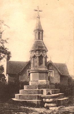
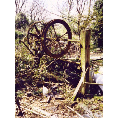
11.1/2. Warren Old Well in ruins c.2000./Warren Old Wellhouse early 20th century.
The occurrence of Epsom Salts in mineral waters is not limited to the Old and New Wells at Epsom. Many similarly charged wells exist neaby, some of which have a clearly defined history, others are merely mentioned in early texts and can not be located or identified today. Bowen's 1753 map of Surrey states that "Mineral Waters, both Purging and Restorative are pretty common in this County; of these the Epsom Waters are the most famous". Alongside the Epsom entry is noted that the waters of this place are said to have been the first of the purging kind discovered in England.[1] As the Epsom Salt bearing strata extend beneath the London Basin, many of the celebrated London spas derived some benefit from the salts also. This explains the location of Acton for the manufactory of Epsom Salt discussed earlier.
It must also be remembered that an extensive tile industry was based on the Reading Beds in earlier times. It was Allen in 1699 who noted that the brown-gray earth of Epsom and Richmond Wells was used for bricks and tiles. The wells were seldom more than 12 feet deep and the loam yields a salt that can be extracted.[2] We can conclude that wherever there was extraction for tile works so there would likely be Epsom Salts springs. This would include Cheam and the environs of Nonsuch Park.
Celebrated springs and wells in the locality of Epsom included the following sites. In some instances the information is sparse and confusing.
Jessop's Well, at Stoke, may well have been a major competitor for the less reliable Old Well at Epsom. The well is situated in the forest at Stoke outside Cobham parish in Prince's Covert, Oxshott. It had similar mineral characteristics to the Epsom Old Well.
In the mid 18th century, the well was described as being on Stoke Common, about 3 miles south of Claremont. James Fox, lord of the manor, had enclosed it before 1739. In the Rev. Steven Hales' review of the waters, published in Philosophical Transactions (1756), Mr Vincent was lord of the manor.[3] Hales' account was published in 1750 according to Whitaker (1912) who gives details as follows:
[4]
It can be ascertained from the version of the Rev. Hales' account published in Philosophical Transactions (1756) that in the well the concentration of the mineralisation was 82 grains in a pound of surface well water on 11th September 1749, after a long period of dry weather. By October 16th following a considerable rainfall, the surface water yielded 60 grains and on the 21st November the surface water yielded 65 grains. On December 11th Hales secured a sample from the bottom of the well yielding 82 grains compared with a surface sample of the same date at 48 grains. He concluded that the surface water was diluted by rainwater penetrating the well. The solution was to dig a deep trench around the well and fill it with compacted clay to give a seal. This would enhance the supply of the preferable, more concentrated waters. The weaker waters were often boiled to fortify them but this led to the active mineralisation being lost or altered by the process. We also learn from the account that it was on October 16th that the well was cleared with such distressing results. This may well have disturbed the natural mineralisation. Dr Adee of Guildford contemporaneously expressed the view that Jessop's Well was an important source of purging water.[5] These accounts likely heralded the launching of Jessop's Well as a spa water of some repute.
The water was being bottled by the 1760s when William Owen was advertising it (see chapter 8); a point confirmed by Hembry. In fact we even know the retail price from the accounts book of a lady, contained in the Furniss Journal held at Bourne Hall Museum. The sum of 2s 6d was paid for Jessop water on the 3rd September 1753, and on the 5th October 18 bottles of the water cost 2s 3d.[6]
Dr Russell, the authority on Epsom and its wells, in 1760/9, posthumously included Jessop's or Stoke Well in the anonymous addendum to his Dissertation on Sea Water. The author recorded that Jessop's was advertised in London in 1750. It was thought to contain more purging salt than any purging water in England. Dr Hales had identified the salt as that of Epsom and the author reviewed a number of tests made to identify the minerals. A gallon of water would yield 1.5 ozs or 742 grains of white salt. Dr Hales confirmed to Dr Rutty in a letter of 1755 that the crystals of salt retained their firmness after 5 years, indicating that experiments were taking place about 1750. A quart of water was sufficient for a good purge. A man, who stood for three hours in the water, cleansing the well, purged severely for a week.[7] Taylor reported that Jessop's water was sold by Owen's Mineral Water Warehouse, the firm that Russell had connections with. Taylor also confirmed that Dr Adee of Guildford had indicated that the water acted smartly with happy consequences for the cautious user.[8]
In 1770 Dr Monro described Jessop's Well on Stoke Common quoting Dr Hales and Dr Rutty particularly. It was a strong purging water with a bitter taste. Monro repeated the story of the purging as a result of standing in the water, also quoted in Dr Russell's anonymous addendum, albeit adding an error. This time it was two people who were charged with the responsibility of cleaning the well, stood in it bare legged for about three hours. As a result they were severely purged. Dr Monro also noted that it was a mild chalybeate, a property lost when dispatched by carriage or when kept.[9] About the same year, Jessop's Well, with an enclosure with two buildings of similar size to the Epsom Wells, appeared on the John Roque map of Surrey dated c.1770.
Other maps that plotted Jessop's Well included Andrew's 1797 map of Mineral Waters, which marked "Jessop's Well or Cobham or Stoke Water".[10] The first edition OS map, 1816, showed Jessop's Well 2 miles NW of Ashtead on Stoke Common, grid ref. 163608.
In the year 1778, John Ellison, a druggist, purchased the rights to Jessop's Well. At the time he was running a mineral water warehouse in St Albans Street, Pall Mall and shortly established a further warehouse at Whitechapel. In 1779 he also acquired the rights to West Tilbury Well.[11]
Like the Epsom Wells, Jessop's Well fell into disuse and in 1871 Dr Macpherson suggested that the remains of an old pump room were in existence.[12] By the end of the 20th century the well house could still be inspected, comprising an isolated 10 ft square brick building with pyramid tiled roof, lancet headed window with bars and door detached from the building. Graffiti suggests a date before 1790 for its erection. The well itself was not accessible but assumed to be under the wooden planks on the floor.
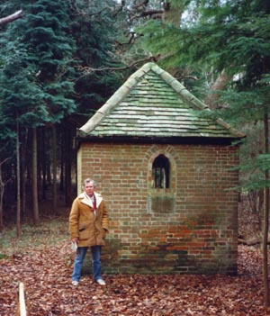
11.3. Jessop's Well with author c.2000.
Slyfield, a well in a nearby parish.[13] Slyfield lies just to the west of Leatherhead and can be identified on Speed's map of 1610.
Epsom: Toland (1711) identified uncertain springs in Church Street.[14] In 1690, jurors of the Court Leet noted that the bridge needed repairing. This likely referred to the Earthbourne; an intermittent spring that formed a stream of a size that justified bridging.[15] The Report of the Commission on the Metropolitan Water Supply (1893) identified an issue of water a third of a mile north east of Epsom Church where water drained off the Tertiary clays and then sank underground.[16] Two intermittent springs are mentioned by Whitaker (1912), being in Church Street and Worple Road, Epsom. Known singularly as the Earth Bourne, it ran for between four to eight months, usually rising just after Christmas. Some years however it failed to appear. It was believed to issue from the Thanet Sands immediately above the chalk.[17]
Details of the Earth Bourne as reported by William Lee (1849) for the General Board of Health are recorded by Andrews (1904). It rose west of the church and flowed intermittently. Some times it was dry for several years but then arose and ran for between four and eight months. It generally commenced soon after Christmas and ran until May or June.[18]
From these reports, which vary slightly in description and interpretation, it can be concluded that the seasonal bourne affected an area of some size before consolidating itself into a clearly defined stream. The "improvement" of Epsom with building development and drainage schemes together with wide scale water extraction means that the bourne is no longer a major consideration. The developers, in their town improvements however did establish two pumps, one at each end of the High Street. In addition the town pond by the Watch House portrayed in old pictures was spring fed.
The Scouring Well in Ashtead Oaks was noted by Macpherson (1871) to have brickwork still over it.[19] The description Scouring Well is also noted in Ashtead Oaks by Sunderland (1915).[20]
This is likely the same well as described in 1676 as follows. Ashtead Well on Ashtead Common was referred to in the 1676 Court Baron for the manor of Ashtead on the 23 June, Robert Downes, William Symes, William Hill, Robert Rogers, George Rouse, Nicholas Seale, William Page and Henry Eastland petitioned for the opening of the medicinal Ashtead Well on Ashtead Common together with about two acres of land to develop facilities. The proposed lease was for 60 years.[21] 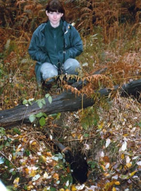
By the mid nineteenth century the well was still noted for its power as an aperient although the brick wall formerly around it had fallen and the well was disused.[22]
Hampton (1977) gives a clearer indication of the well on Ashtead Common. It was located near the remains of the Roman Villa and Bath House, suggesting that it may have Romano-British significance. The site of the Villa lies to the north west of the village in an area that was once covered in heavy oaks. There is a modest hill and the mineralised spring rises on the north-western slope. This is about 2 km. west of the Epsom (Old) Wells. It appears on the 1867/8 6 inch OS map and is mentioned in Victoria County History. There is little doubt that this well was used to supplement the supplies to Epsom (Old) Wells from time to time.[23]
11.4. Vicki Forbes, Community Woodland Officer at Ashtead Well, 1996.
R B Adamson (c.1996) produced a useful account of Ashtead Well for the Corporation of London who own the common. The present author's comments are in square brackets.
Jessop's Well on Stoke Common is noticed by the Rev. S. Hales who found that the bottom-water of the well (about 10 feet down) near the spring was stronger than the surface-water. He says that "the Quantity of purging Salt in this Water is considerably greater than any other" and that it is "observed to exhilirate those who take it."
"When Jessop's Well was cleaned.... after about half a Foot Depth of black muddy Filth was taken out, then the natural fat sandy-coloured Clay-Bottom appear'd; thro' several Parts of which the Water ouzed up at a Rate of 160 Gallons in 24 Hours."
"It was very observable, that the Man who stood about three Hours bare-legg'd in this Well-Water to clean it, was purged so severely for a Week, that he said he would not venture, on any account, thus to clean the Well again. And it was the same with another Man, who cleaned the Well about twelve Years since." "Most regular users of Ashtead Common will probably have visited the sites of the Roman Villa and the Earthworks, whose positions are indicated on the large maps on the notice boards at the principal entrances to the common. I suspect that few will know of an old well, which is situated a little to the north of these sites. The position of the well, NGR TQ 176603, appears to be shown on the detailed OS maps, where it is identified as a spring. There is no evidence of surface water flowing away from the well, but, in winter or in wet spells, a trickle of water can be observed emerging from the ground 100 yards north of the well. (The ground slopes gradually downward from the well to this point). The trickle of water gradually increases as it flows northwards and, in winter. it is recognisable as a small stream by the time it reaches the northern boundary of the Common. It is very likely that there is a connection between the water in the well and the water starting to appear on the ground, but the connection is now presumably by underground seepage. Before the well was built, the seasonal spring may have come to the surface at the position of the well.
The present well construction does not rise above the level of the surrounding ground and is inconspicuous. A cursory examination indicates that it is of unusual shape, with a shallow hole about 1ft square and an approximately semi-circular main hole [this is the main well and has the remains of a brick dome cap which has partially collapsed], measuring about 3ft at its widest. [the two cavities described are adjacent, a further unexplained circular depression about 5ft in diameter and 1.5ft deep is about 10ft away]The present maximum depth of the water in the main hole is about 6 feet, but it is likely that it was originally deeper, as debris will have fallen into the hole since it was last cleared out. Red brick is much in evidence in the construction. The level of the water in the well reaches to a few inches below ground level in winter, but can drop considerably in summer. There is also a seasonal variation in the clarity of the water, from very cloudy to sometimes quite clear and bright. The water tastes slightly saline, but not particularly bitter.
A partial chemical analysis of the water, sampled in July 1993 from near the surface of the well, indicated that Epsom Salt (magnesium sulphate heptahydrate) was the principal salt present, at a concentration of about 2g per litre. Other sulphate salts were also present to the extent of about 1g per litre. It is likely that the concentration of the salts will vary, depending on the weather, time of year and depth at which the water is sampled. The results indicate that the water is similar in general nature to that from the famous old Epsom well at the time of its popularity, but the concentration of salts in the Ashtead well is lower.[this is likely due to an accumulation of surface water in the Ashtead well] In the late 17th century the concentration of salts in the old Epsom well appears to have been around 7g per litre (See the booklet "Epsom Wells" published by the Borough Planning Dept. of Epsom and Ewell Borough Council, 1989, page 44. [Exwood M. 1989]. However the same publication also shows a total solids content of only 3.2g per litre for the water in the old Epsom well when sampled in 1987, and a magnesium sulphate content of only 1.42g per litre for water sampled in 1989. [Such sampling may also have been affected by surface water ingress and accumulation] The results suggest that the salts content of the groundwater around the site of the old Epsom well has lessened in the intervening years. Even at its present concentration the salts content from the Ashtead well makes it totally unsuitable for use as a regular drinking water, and it would act as a purgative if a large volume were drunk. An interesting, and fortunate, observation is that, although water containing sulphates, especially magnesium sulphate, can cause serious attack on buried concrete made with Portland cement, I have not heard of any special problems of this kind with the foundation concrete of houses surrounding the Common.[This would only occur if they penetrated the aquifer beds of the mineralised water] It seems that the foundations do not quite get down to the depth where the bulk of the sulphate is present, at least in those areas where houses have so far been built."[24] Adamson goes on to suggest that the well may have been used for scouring livestock during the eighteenth century, in the interests of good animal husbandry. This would be carried out to stock grazing the common and would have given rise to the use of the name. Such a practice could well have been subsequent or coeval with the use of the waters for medicinal purposes.
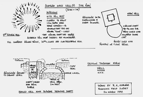
11.5. Site plan and cross section of possibly two wells in Ashtead Oaks following a field survey in 1997.[25]
Wells are shown on the 1871 and 1897 maps of Ashtead in Rectory Lane, Skinners Lane and Woodfield Lane. These are likely domestic wells for local use.[26]
11.6. In The Street at Ashtead lies the attractive Almshouses, founded by Lady Diana Feilding in 1730, and added to by her successor Lady Mary Howard of Ashtead Park. Opposite lies the Howard Memorial with fountain erected in 1879 in memory of Lady Mary.
In 1773, Dr Dale Ingram in Gentleman's Magazine, commented on a new well sunk at Epsom in 1767. The depth was 39 feet and it contained about 26 feet of water. Comparisons were made with Harrogate water. The water was described as fetid and suggests a highly contaminated source. The location is not stated.[27]
The Old Well at The Warren, Langley Vale, up on Epsom Downs, grid ref. TQ 213575, was traditionally founded in 1666 by Charles II and 480 ft deep. This story is frowned on by historians and local residents are seeking a more accurate history. What is apparent is that the well was dug at some expense for the use of the visitors to the downs. It was there before Lord Baltimore built The Warren, since the shape of the enclosure has been modified to allow access.[28] Its use suggests that it was post the spa main era, when horse racing attaracted enormous crowds. The Warren was set up in 1720 by Lord Baltimore for spa visitors and its attractions included hare coursing, making the well late 17th or early 18th century.
An early 20th century postcard shows the Well open to the public. Being a substantial well, it would have produced a plentiful supply of deep water with characteristics associated with the chalk geology of the region.
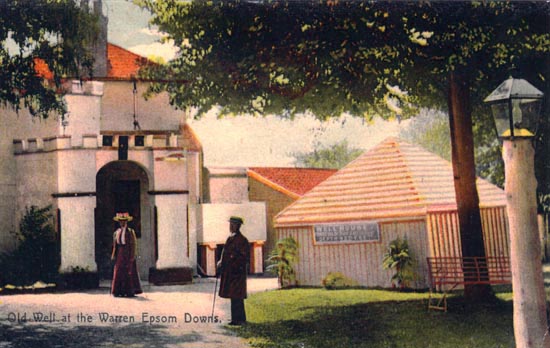
11.7 The Old Well at The Warren, circa 1900.
In 1839 what is described as "a well near the racecourse" suffered the occurrence of carbonic acid gas (carbon dioxide) at a depth of 200 feet. The outcome was fatal.[29]
The Well by the end of the 20th century was in a sorry condition. It forms part of a yard for racecourse maintenance equipment. The winding gear is still in situ but exposed to the elements. The well is capped in concrete. Thames Water Inspectors have apparently tested the Old Well and found it to be some 350 deep and dye dropped into it eventually emerged in the horse pond in Ewell village. Urgent preservation is required for this listed building and artifacts and to this end Brian Angrove, Chief Conservation Officer of Epsom and Walton Downs hopes to landscape the area.[30]
COBHAM MEDICINAL WELLS
There are two distinct sites in the vicinity of Cobham, one north west of the village and one to the south.
South - A medicinal well existed at Goose Green, Downside, Cobham, apparently discovered in 1670. This well in marked on the early 19th century old series edition OS 1" to the mile map as "Well House" and is just to the south of the hamlet of Downside, south of Cobham. Taylor (2003) reproduces a picture of the cottage and well taken circa 1930. In 1673 John Aubrey gave a description of the well saying that it was a medicated spring similar to Epsom. It had been discovered three years earlier by a countryman who used it in his food and for feeding his pigs. At the bottom of the well were stones like Bristol diamonds; colourless quartz crystals worn by ladies.[31] This site has been obliterated by the M25 motorway, which transformed the landscape.
 North west - Spa Bottom Well or Fairmile Water, which enjoyed a brief 18th century fame as a spa. The wells and the spa were reported by Taylor from the Universal British Directory of 1793. Located at Spa Bottom on the Fairmile, in 1736 it was noted as of the Tunbridge kind (chalybeate). Fairmile water exceeded that of elsewhere in virtue.[32] Dr Munroe, in 1770, recorded Cobham as a chalybeate well with sea salt.[33] Another doctor, John Elliot (1789) also described Cobham as a chalybeate well but "rather stronger of the iron" than Tunbridge.[35]
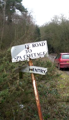
The site can be identified as Spa Cottage which lies adjacent to the Esher Bypass on the northern side. Access is by private drive on the eastern side of the Portsmouth Road, where it bridges over the bypass. This well is believed to have survived in the gardens of the house where a pungent well was inspected by this author in the 1990s.
11.8. End of the road for Cobham Wells - all that is left to remind of an earlier spa era. The private access to Spa Bottom.
By the late 18th century, both Cobham sites were less resorted to at the time (1793) because of Jessop's Well that was nearby.[34] Elliot reports about the same time that nearby was another purging water which was tested by "Dr Hals". This is a reference to Jessop's Well and Rev. Hales detailed earlier in this chapter.[35] Rattue gives grid references for the two Cobham sites. The southern site is given as TQ 107578 but is believed to be slightly to the west of the actual location. The north western site is given as TQ122621.[36]
Click on website below to return to Index and Introduction.
Website: Click Here
SUPPLEMENTARY INFORMATION
1) TOPOGRAPHICAL LOCATION:
England
3) INFORMATION CATEGORY:
Springs and Wells General InterestHistory & Heritage


