| 
|


Limekiln Spring
NGR 76157 44492
Site Number: C45
By Bruce Osborne and Cora Weaver (C) 2012
Area 4. West Malvern Springs and Wells
Malvern Hills, England
Description: a spring emerging to form a brook.
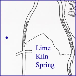
To find the Limekiln Spring, continue south along West Malvern Road and turn right into the very rough track known as The Purlieu. Follow The Purlieu downhill and at the T-junction at the bottom turn right into Brockhill Road. About 100m uphill on the right are the old limekilns; a further 50m up on the left is a signpost and stile for the Worcestershire Way. Cross the stile and walk at a 25 degree angle to your right as far as the field boundary, 150m away. The spring rises on the other side of the fence.
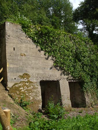
The uneven landscape in the trees on the hill side in Brockhill Road is evidence of the limestone quarrying. In the 19th century men dug and horses pulled cart loads of rock from the quarries to the tops of the kilns, where it was thrown in. As the kilns were filled with alternate layers of limestone and coal, fires were built to reduce the stone to quicklime. Once fired, the lime was used in agriculture and, until the 1930s, lime mortar, which was an essential part of the building industry. The water of Limekiln Spring was likely supplemented with waters from the racing Purlieu stream to supply steam-driven machinery and to water the horses
The 1633 enclosure map of Malvern Chase shows a spring rising at 'The Gould Pitt' (now known as The Gold Mine, 350m north of the Wyche Cutting), and its stream running west past St Thomas's Well, where the Royal Malvern brewery and bottling works was later built, and down the Purlieu.
There used to be an open well in the Purlieu, near the lime kiln, which supplied drinking water to some of the houses in the Pulieu. It was c.1905 that some of the cottagers who lived above the well decided to stank the nearby stream to form a duck pond, but unfortunately when it rained hard the pond overflowed, The water ran down the road, and polluted the well. The Purlieu residents complained, as did Hugo Martin, whose cattle drank from the same water. This is one example of how easy it was to pollute drinking water and perhaps cause illness.
llustrations:
1. The Limekilns, before landscaping in 2011.
2. The Malvern Hills Conservators map showing the geography of the area.
3. Limekiln Spring.
Footnotes:
[1] Explore Wyche and Purlieu Trail, (2003) Herefordshire and Worcestershire Earth Heritage Trust.
Website: Click Here
SUPPLEMENTARY INFORMATION

Celebrated Springs of
THE MALVERN HILLS
 A definitive work that is the culmination of 20 years researching the springs and wells of the Malvern Hills, published by Phillimore. This is the ideal explorers guide enabling the reader to discover the location and often the astounding and long forgotten history of over 130 celebrated springs and wells sites around the Malvern Hills. The book is hard back with dust cover, large quarto size with lavish illustrations and extended text. Celebrated Springs contains about 200 illustrations and well researched text over a similar number of pages, together with seven area maps to guide the explorer to the locations around the Malvern Hills. It also includes details on the long history of bottling water in the Malvern Hills.
1) TOPOGRAPHICAL LOCATION:
Malvern Hills - arguably Britain's original National Park
2) LANDSCAPE:
Farmland3) INFORMATION CATEGORY:
A Spring, Spout, Fountain or Holy Well Site4) MALVERN SPRING OR WELL SITE DETAILS:
Site with Malvern Water3 SPLASHES - Of Moderate Interest

5) GENERAL VISITOR INFORMATION:
Access On FootOn Private Property
Accessible All Year