| 
|


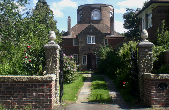
 Tadworth Water Tower
Tower House,
Tower Road
Tadworth
Surrey
United Kingdom
KT20 5QY
Telephone: 01737 213169
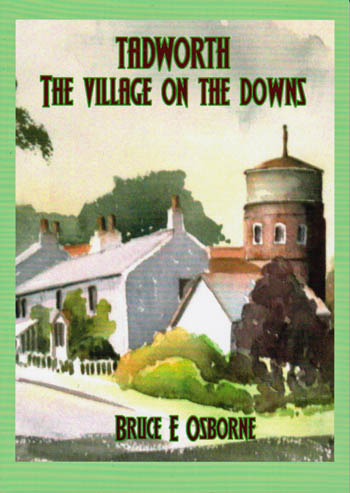
by Dr Bruce E Osborne.
The North Downs Location
The Tower House in Tower Road, (formerly Middle Road) Tadworth is now a distinctive residence. It started life as a water tower for the Sutton District Water Company who built it in a Victorian Romanesque style in 1898. Although the Tower was essentially an industrial building, it was also a prominent tourist landmark on the edge of Walton Heath. The background to tourism interest was that in the previous year the Chipstead Valley Railway, incorporated by Act of Parliament in 1893, had opened to Kingswood Station. The Act gave powers to build a line between Purley and Walton on the Hill. As the line was extended, Tadworth railway station was opened on 1st July 1900 as "Tadworth and Walton on the Hill". As a result the locality became prime development land as well as a venue for excursionists who dispersed over Banstead, Walton and Headley Heaths. A characteristic feature of the local heaths and the land upon which the tower was built is that the surface geology comprises clay with flints of Pleistocene and recent origin overlying the Upper Chalk of the Cretaceous period. This gives the heath a distinct bio-diversity and topography. Picture: This was the Tower that ramblers would walk to from the newly opened station of Tadworth and Walton on the Hill. 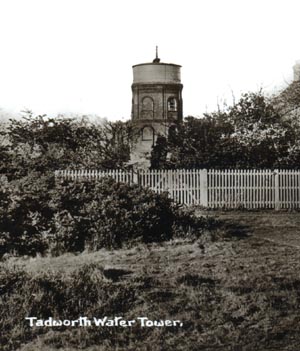
Colley Hill, on the nearby south-facing escarpment of the North Downs, became popular in the 19th century, together with the more distant Box Hill. The latter venue had a long-standing reputation for diversion and debauchery. The Earl of Arundel, during the reign of Charles I (1625-1649) is reputed to have brought Box trees from Kent and planted them on White Hill, later renamed, although evidence exists to suggest that Box trees on the hill predated this. In the 18th century, the Box Wood was considered the best in the Kingdom. Mackay (1714) observed that "Gentlemen and Ladies insensibly to lose their company in the pretty labrynths of Box-wood and divert themselves unperceived....and it may justly be called The Palace of Venus". Celia Fiennes, c.1692, noted Box Hill as a diversion for visitors to "Epsum Spaw" and Daniel Defoe, 1724/6, saw the walks laid out by the Earl of Arundel as a place to divert or debauch, or both.
The Health Resort
Tadworth in the 18th century enjoyed a different type of reputation and is described by Aubrey as "famous for its wholesome Air, once perscribed by Physicians as the patients last refuge or Ultimum Refugium". Perhaps as a reaction to the earlier excess associated with Box Hill, by 1905 Tadworth sported a Temperance Hotel, run by Mrs Effie Smith. Walkers were attracted to Tadworth by the healthy scent from the pine trees that grew in profusion together with the bracing air of the North Downs. The district was  sparsely populated and the Tower, as a landmark, was featured extensively on post cards of the era.
Tourist Souvenirs
A trade in tourist souvenirs developed alongside the travel and refreshment facilities. Armorial china was a popular recreational tourism keepsake. Two Tadworth retailers sold such souvenirs, W.Gates at The Bazaar and Simpson of The Paragon (later the Willow Cafe). Items included a charabanc, which suggested that the railway was not the only mode of transport for the visitors, and Epsom Clock Tower (built 1848), indicative of the importance of Epsom as the nearest town. Tadworth had no official coat of arms and one was contrived in due course. 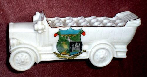 The use of the castle from the County armorial on a model of Epsom clock tower suggests that this may be an earlier item and that later a more complex design was created.
With the coming of the railway, the deep cutting and Tadworth Street bridge were notable features and were depicted on a new contrived arms, together with a country lane, probably also Tadworth Street looking south, emphasising the rural aspect of the neighbourhood. Walton on the Hill similarly had a trade in designated armorial china. Enterprising local people set out to capitalise on the tourism. A mobile snack bar from this era survives in Walton, now a garden hut opposite the Chequers public house.
The Commons
Walton Heath and Banstead and Epsom Downs were long established as local venues of outdoor recreation before the erection of the Tower. On 14 July 1667, Samuel Pepys records that he travelled by coach from London to spend the day at Epsom, taking the waters and walking on the Downs where he met a shepherd and lad with a sheep dog. For 4 shillings a week (20 new pence) the shepherd tended 18 score sheep the year round. Aubrey (1718/9) noted that Banstead Downs was famous for its wholesome air and was well renowned for mutton. Gilpin, in contrast, on his August excursion of 1768 recorded Walton Heath as "a wild and desolate view. Nothing can be more dreary, and comfortless. A solitary wind mill and a spire tell you that the country is inhabited." This was Tadworth Mill and Walton Church as they were then.
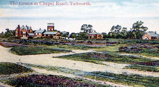
Picture: The Common circa 1910 showing the tower from the south-west.
Banstead Downs or Commons today form an important recreational facility. To the south of the Tower lie two adjacent areas of open common land with freedom to roam. Immediately to the south is Banstead Heath, the largest of the four separate areas, which aggregate to form Banstead Downs, and then further south lies Walton Heath. The other two areas are Epsom Downs and Banstead Down at Belmont. All of these areas have been threatened with enclosure in the past and the Banstead Commons were the subject of particularly pertinacious litigation between the years 1877 and 1889.
In 1864, Mr Alcock, the Lord of the Manor, sought to enclose the four commons but abandoned the attempt due to local opposition. Following Mr Alcock's death in 1866, a further attempt of enclosure failed by his executors and his interests were sold to Sir John Hartopp in 1873. By 1876, Sir John had purchased sufficient commoners rights, almost regardless of costs, to prompt him to build a row of houses and enclose part of Banstead Heath under the Statute of Merton. This provides for the land to revert to private property if all commoners' rights are extinguished, thereby enabling enclosure under common law. A newly formed Banstead Commons Protection Society set out to oppose such enclosure by securing commoners rights and commencing a suit against Sir John in 1877. Lord Egmont owned three of the four dependent manors of Banstead including South Tadworth and faced with possible damaging enclosure of adjacent land, he cooperated initially with Sir John Hartopp. There followed a maelstrom of litigation culminating in Sir John's legal advisers becoming insolvent and Sir John in turn facing ruin and bankruptcy. This prompted the new Lord Egmont to relinquish his loyalty to the Hartopp cause, which if successful, such loyalty would have been rewarded by extended land ownership. It then transpired that the commons had been mortgaged to two ladies, who on Sir John's bankruptcy, took possession of the commons and in turn pursued the suit for enclosure. It was in 1886 that the case finally came to court and the ruling was in general favour of the commoners, although the question of surface damage recently affected by the two ladies was left unresolved, pending an investigation into the amount of commons needed for commoners husbandry. Lord Egmont's substantial grazing rights proved of value in this argument and following an appeal, the claims of the commoners were vindicated on 21 Dec 1889.
In 1893 the Banstead Commons became regulated under the Metropolitan  Commons Act and thereafter were secured for all time. The adjacent Walton Heath however did not enjoy such protection and this was the subject of a determined effort at deregistration by the Walton Heath Golf Club, which had enjoyed use of the Heath, subject to commoners rights and public access under the Law of Property Act 1925. With the coming of the M25 motorway, the Club saw the opportunity of renegotiating the three remaining commoner's rights in exchange for a financial consideration. Rapid intervention by local residents intercepted the intention with the result that the Club could only secure one of the three rights of common. Once again efforts at deregulation had been thwarted.
The Railway
The first scheme to bring the railway to Tadworth was an unsuccessful 1884 bill for a line through Chipstead promoted by local farmers. Cosmo Bonsor (born 1848), financier, director of the Bank of England and MP, together with J W Benson, a Bond Street jeweler and W S J Brown, a retired corn chandler shortly afterwards promoted an alternative scheme. This was based on connecting the London, Brighton and South Coast Railway branch to Epsom Downs with a branch line from Drift Bridge to Corner Farm, Tadworth. Although land values soared as speculators moved in, one opponent was Frederick Coleman of the mustard firm who owned land on the planned route. In spite of this the Epsom Downs Extension Railway Bill received Royal Assent in June 1892. The first sod was cut on 6 June 1892 but apart from this little work progressed.
The reason was that Cosmo Bonsor had turned his attentions to the earlier Chipstead scheme as a means of avoiding local landowner opposition. Connecting with Purley, the Chipstead Valley Railway Act was approved in 1893. Bonsor joined the Board of the South Eastern Railway who operated through Purley, and was chairman by 1898. Work progressed with the new railway reaching Tadworth in 1900. The section of planned railway from Drift Bridge to Tattenham Corner was abandoned by Act of 1897 and Tattenham Corner eventually became the terminus for the Chipstead line. The extension of the railway to Tattenham Corner in 1901, for race and leisure excursions to Epsom Downs, enhanced the potential for outdoor recreation considerably. After 1899, the South Eastern and Chatham Railway Company operated the line and a free season ticket was offered for one year to London as an inducement to encourage residential traffic. Royal patronage of the Derby, traditionally visited by train, furthered the popularity of the locality.
In 1997 a train was named "Sir Cosmo Bonsor" in recognition of his services.
Horse racing
Horse racing on the Downs likely originated from the Royal patronage associated with Nonsuch Palace in nearby Ewell in the 16th century. The vast numbers of horses congregating at Epsom during the spa era inevitably led to the occasional wager and a testing of speed across the downs. Throughout the 17th century regular racing took place first on a straight 4 mile course. Since then there have been various layouts, in spite of the Grand Stand retaining its position, eventually resulting in the well known "horseshoe" shaped course of present times. Epsom Downs remains one of the great horse racing centres in the world and the racecourse maintains its tradition of free public access. The Derby, one of the greatest races in the sporting calendar and The Oaks 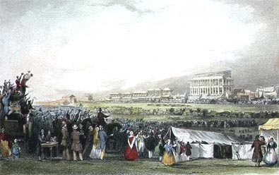 give rise to a week of racing and associated activities that attract vast crowds in a unique open-air festivity. Both races are named after Lord Derby who at the time resided at Oaks Park, Carshalton.
Picture: 19th century racing day on Epsom Downs.
Epsom Spa
Epsom, the local town, enjoyed a reputation as a spa after the discovery of the mineral waters in the late 16th century. It was probably this that established the locality as an area of recreation more than anything else. By the end of the 17th century the town had been extensively developed as a place of healing and pleasure, enjoying noble patronage. The celebrated Epsom Salts, magnesium sulphate, received world wide acclaim. The original well was located on the open common about 1 mile out of town. Similar wells also existed at Ashtead, which were used for replenishing the old well, which often went dry. In the early 18th century, Epsom attracted capital for infrastructure investment and new spa facilities were established in the town. In due course the original well closed. After suspicions of spurious water at the New Wells and doubt about the efficacy of artificially produced Epsom Salts, the town lost its good reputation. This coupled with increased mobility rendered Epsom less desirable as a resort. After about 1730, Epsom had ceased to function as a spa and the area developed as a residential locality with good access to London.
Ancient Tadworth
The first records of South Tadworth go back to the Norman Conquest. Known as Tadeorde, William the Conqueror granted it to his half brother Odo, Bishop of Bayeaux, who sub let it to one Ralph. At the time of Edward the Confessor, it is recorded that two brothers held it.
In medieval times the Priory of Merton owned South Tadworth. A John Gyllum is placed outside the tything of "Tawworth" in 1378 and Thomas Gillen is referred to in the Tadworth Court Roll of 1393 and either may be the origin of the Gillums field name, the location where the tower was subsequently built. At the time of the dissolution of the monasteries, John Steward had a 21 year lease dating from 1535. With the dissolution, South Tadworth formed part of the lands known as the Honour of Hampton Court, which included Walton on the Hill, with Steward retaining his tenancy until his death in 1551. In 1553 the land was acquired by Edward Herrendon passing to his son Henry and grandson Edmund Herrendon. Edmund sold it in 1620 to a salter of London, George Hawes who in turn disposed of the land 11 years later to Sir Thomas Chrymes, a contemporary of John Evelyn, the diarist. In 1648, Robert Wilson purchased the manor. 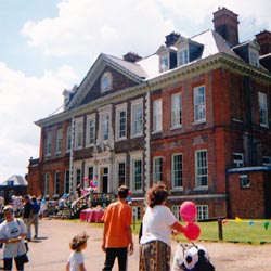 The Wilson family retained the land until 1694 when it was sold to a merchant, Leonard Wessell, who built the Manor House, subsequently known as Tadworth Court, about 1700.
Picture: Tadworth Court, circa 2000.
Charles George, whose family name was Perceval, was the 2nd Baron Arden and 7th Earl of Egmont. The family resided at Nork Park, also purchased from the Buckles in 1812. The family arms are "Quarterly; 1st and 4th argent, on a chief indented gules, three crosses patee of the field". Born in 1845, Charles was the son of the Rev. Hon. Charles George Perceval. In 1869 he married Lucy King and became MP for Midhurst in 1874. He died in 1897. The Earldom, which is a peerage of Ireland, dates back to a grant of 1733. Before this the family enjoyed a hereditary Baronetcy that dated from 1661.
The Nork Park Estate was sold by auction on 14 July 1890 by Messrs. Beadel & Co. Lot 570 on the "Plan of the outlying portions of the Nork Park Estate" was Gillam's Field. Comprising an area of 9 acres 6 poles, it was part of Corner and Profits Estate Farms. Three land speculators, Alexander, Lefrey and Benson, purchased Gillam's Field, which included the land on which the Tower was later to be built. Benson subsequently acquired the full title from Alexander and Lefrey in 1897. Benson in turn transferred the land to the Tattenham Park (Epsom Downs) Land Co. in the same year.
As the railway opened up the area the process of development ensued. What was once an outlying portion of the Nork Park Estate now became prime development land. Such expansion needed services to accommodate the growing populace including the necessary supply of water. The North Downs is not 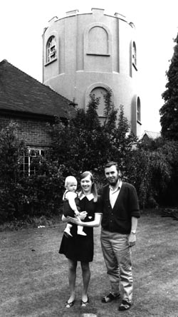 noted for its easy access to water and so it was the spring line at Sutton, to the north, that was to be the source of potable water.
Picture: The author Dr Bruce Osborne and family at Tower House, 1971.
Water Supplies
The land on which the Tower was to be built, measuring about half an acre, was acquired from the Tattenham Park (Epsom Downs) Land Co. by the Sutton District Water Co. in 1898, for the erection of the water tower. This plot corresponds roughly to the present nos. 11a 15 and 17 Tower Road although the tower now stands on no.15. The Land Company had previously acquired the plot as part of the Corner Farm estate for general development. The Water Company's intention was to supply water to the surrounding district, which was being developed, particularly to the north and the tower was built in the same year of 1898.
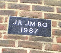
Piped water first came to Tadworth as a result of the earlier efforts of the Lord of the Manor, Mr Tritton in 1881 when the Sutton District Water Company laid on a supply to Tadworth Court. Before that the town pond in the Hoppety had been the main source of water together with a substantial well at Tadworth Court. Seventeen years later the new water tower enabled the service to be considerably extended. 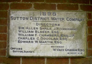 A foundation stone for the Tower, made in marble with leaded characters and unearthed in the garden in 1970, confirms the date of erection. It includes a list of the principals of the Water Company.
The half yearly reports of the Water Company make mention of the construction work, including the costs. These were published in the Sutton Advertiser on 5th February and 6th August 1898:
£429-9-6 on erection of the Water Tower at Tadworth; 54th half yearly report.
£656-14-11 on completion of Tower at Tadworth; 55th half yearly report.
According to Slade and Church, estate agents, by 1925/6 residents were being charged for their water at a rate of 71/2 percent in the £, compared with domestic rates (the local authority tax at the time) of 10/- or fifty percent in the �£. The percentages were assessed against a theoretical ratable value for each property calculated from its market worth.
During landscaping work in the year 2000, a brick underground structure located in the garden of Tower House, was explored further. This proved to be a brick lined shaft of considerable depth. The infill, which contained materials similar to those used on the house, suggested that the shaft had been backfilled in circa.1926, when the house was built. The shaft is believed to be a well dating from the 19th century. The well in the garden of "Studium" 21 Tower Road, some 60 yards away, 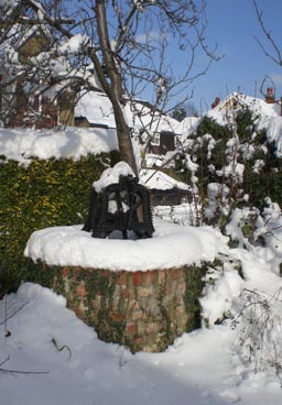 was 180 feet deep before infilling. The Tower House well is likely of similar depth. A new wellhead was constructed to celebrate the Millennium.
Picture: the well head in the garden, winter 2010/11.
Background to the Water Company
The Water Company was inaugurated on the 15 June 1863 as the Sutton and Cheam Water Co. Ltd. In 1871 the Sutton and Cheam Water Co. was reorganised under the Sutton District Water Co. following the acquisition of statutory powers through Act of Parliament. The list of Directors featured on the foundation stone is indicative of the reorganisation that took place of the SDWC in the early 1870s. Sir Allen Sarle was recruited in 1870 and served as Chairman until 1903. William Blaber was also recruited in 1870, from Brighton, Hove and Preston Water Works where he had been chairman.
A red granite public drinking fountain and basin set in the North Gate of the Royal Pavilion at Brighton commemorates William Blaber's services to Brighton. The North Gate of Brighton Palace was built in 1832 for William IV. He was the brother of George IV, formerly the Prince Regent. William first visited Brighton as the Duke of Clarence but on succession in 1830 further developed the Pavilion. He was a regular visitor to Brighton, often strolling along the Chain Pier or through Kemp Town. The site of the fountain, on the Gate, was clearly a prestigious position.
The Brighton, Hove and Preston Waterworks Company was formed in 1834 to provide a public water supply to that locality. Two water supply company reorganisations took place, which were contemporary with William Blaber's association with Brighton. In 1853 the Brighton, Hove and Preston Constant Service Water Supply Company was formed to be superseded by the Brighton Water Corporation in 1872. William Blaber was 36 years old when he became Deputy Chairman of the Water Company in 1854 and the fountain was erected 5 years later.
After Blaber left the Brighton Water Co. at about the age of 54 he joined the then Sutton and Cheam Water Company in time to participate in its reorganisation as the Sutton District Water Company in 1871. It is likely that with both Brighton and Sutton undergoing reorganisation there was a period of overlap of responsibilities. He served the SDWC until 1903 when he died, having just succeeded as Chairman at the age of 85.
The Brighton fountain inscription must have been in memoriam to a man who devoted his life to the provision of public water supplies. The fountain is now dry and neglected.
Other Directors featured on the Tadworth Water Tower plaque include William Chambers, recruited in 1880, Chairman from 1904-1905 and serving until 1907, Charles Douglas who served from 1889-1901 and the Consulting Engineer, Vaux Graham, who served from 1896-1940. In all five new Directors were appointed in 1870 when the company restructured, although only two remained by 1898.
The Tower Specifications
The Tower, built at Tadworth, comprised a riveted steel tank on a brickwork supporting structure. It was supplied by water pumped from the SDWC works in Carshalton Road, Sutton. This necessitated raising the water approximately 500 ft to achieve a top water level in the Tower 641 ft above sea level. The tower was originally about 50 ft high including the tank, 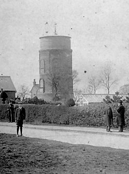 which was 11 ft in depth, and with a diameter of about 24 ft. The brickwork was styled on a three tier, six sided, configuration with arches and windows at each level. The bricks used were red, yellow and blue to give an unusual, yet colourful appearance.
Picture: Tower circa 1911.
In 1910 the SDWC acquired the Kingswood and District Water Co and in order to meet the demands of the new area, a second tower was built at Colley Hill in 1911. This tower, standing in Margery Wood, is still in use today, and is now adjacent to the M25 motorway where it can be seen on the south side.
The capacity of the Tadworth tower was 20,000 galls (90,922 litres weighing 91 tonnes), however by 1912 only 18,000 galls was effectively used. This was as a result of the additional pumping pressure to Margery Wood making it necessary to reset the ball valve at Tadworth. An engineer's report of the time indicates that in spite of the Margery Wood tower, demand for water resulted in the Tadworth Tower being dry for considerable periods during the day and night. A proposal considered in 1912 was the provision of a further reservoir at Margery to supplement the Tower.
A typical analysis of Sutton water used in the Tower is given by Suckling (1944).
p.p.100,000 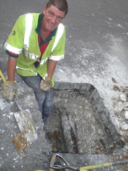
Calcium Carbonate 23.7
Calcium Sulphate 3.1
Calcium Nitrate 8.2
Magnesium Chloride 1.8
Sodium Chloride 2.25
Sodium Nitrate 2.9
Silica,organic matter,etc 2.55
Total 44.5
Total Hardness 34
Free Ammonia .000
Albuminoid Ammonia .003
Oxygen absorbed .066
Picture: In July 2009, excavations in the pavement at the gated entrance to Tower House revealed a 6 inch iron pipe, one of the original service pipes to the water tower.
The background to the Sutton District Water Company.
By 1861, Sutton, once the smallest of villages along the spring line, had begun to take precedence over its neighbours. The population of 3186 exceed that of Carshalton, whose many mills and varied industries had, until the mid 50s, made it the busiest and largest local community. Sutton had begum to grow with its importance as a convenient breakfast stop for Brighton bound coaches and had even had a certain glory while �Gentleman� Jim Jackson was landlord of The Cock and the Prince Regent called regularly to patronise his ex-pugilist acquaintance.
The opening of the Croydon and Epsom Railway in 1847 marked a further stage in the progress from village to town. So did the business acumen of Thomas Alcock, Lord of the Manors of Sutton, Banstead and Kingswood from 1845 to 1865. Alcock, who resided at Kingswood, divided much of the manorial estates in his most northern property into building plots and sold them off to willing developers. Some of the profits from his enterprise were returned to the growing village in the form of generous contributions to the rebuilding (in 1863) of the parish church, and to the endowment of All Saints Church at Benhilton.
In common with the other villages now in the borough, the original settlement had been on the relatively narrow band of Thanet Sand that divides the chalk of the downs from the clay of the London Basin. Here a water supply was readily available, which, having percolated through some hundreds of feet of chalk, was almost completely free from impurities. Settlement of the north involved the use of surface wells, while to the south, the higher up the downs that one built, the deeper the wells had to be.

The purity of its waters, at a time when many Londoners were drinking untreated water straight from the Thames, was perhaps the reason for the tradition of healthiness of these villages along the dip slope of the downs. Eighteenth century physicians proclaimed that the Banstead Downs were the patients last refuge. This is the reason for the fine 18th century mansions that remain at Carshalton, Ewell and Epsom, and once were a feature of Cheam and Beddington. Sutton is less generously endowed with waters, and development had been blocked on the eastern side of the High Street by the grounds of the Manor House, so that the original village was confined to the western side of the road and reached from Sutton Green to about half way up the hill towards the Cheam and Carshalton cross roads. All this was changed in 1863 with the formation of the Sutton Water Company. With a spreading system of water mains there was now no hindrance to expansion.
Between 1851 and 1861 the population doubled and during the next decade it doubled again. Estates were laid out in the new town district of Lind Road and Carshalton Road, on former manorial lands, while what had once been common land in Benhilton became covered with houses. In the High Street, houses and shops extended southwards beyond The Cock, as far as the newly established Toll Bar on the Brighton Road. In 1867 the second rail link via Carshalton and Peckham increased the accessibility of the region; and the public hall, opened in 1877, added to the amenities. By 1883 in less that 30 years, the village had become a town of over 10,000 inhabitants.
Such rapid growth inevitably brought social and environmental problems. House building often outstripped the supplies of piped water. Robert Smith, historian, recall that when his mother came to live on a large estate in 1876, she was allowed only one pail of water a day from the pump for drinking and cooking; other requirements had to be met from the water butts and the pond.
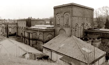
Picture: The Pump Houses photographed shortly before they were demolished in the mid-1980s. From here the company would have pumped water up to the Tadworth Tower.
The first mains were laid along the Cheam and Carshalton Roads and in the Brighton Road, with a reservoir at the junction of Brighton Road and Ventnor Road, which remained in use until it was superseded in 1927 by a large reservoir at Nork. The system was extended rapidly; during 1967 water was supplied to parts of Carshalton and Malden parishes, and by 1869, 27 miles of mains had been laid. In May 1871 the Sutton and Cheam Water Company became the Sutton and District Water Company and was granted statutory powers by a special Act of Parliament to supply the parishes of Sutton, Cheam, Carshalton, Wallington, Beddington, Morden, Banstead, Woodmansterne, Ewell and Cuddington. Except for the addition of Kingswood, whose water company was purchased in 1910, these limits remained unchanged throughout the 20th century. The works undertaken over this large area led to a considerable reduction in profitability. In 1881 a balance of profit of £1 19s 5d was brought forward from the previous half year. There were other troubles.  The Southwark and Vauxhall Water Company attempted in 1889 to sink wells in the Sutton area. The proposal was resisted, not only by the directors of the company, but by the many mill owners along the River Wandle who were dependant on spring water to turn their water wheels. By 1900, 142 miles of mains were in use but three years of drought brought further problems, and in 1902 wells had to be sunk at Woodmansterne and new works were established there.
By the beginning of the 20th century, the Sutton and District Water Company was delivering through its network of 142 miles of mains a total of 1.3 million gallons daily to a population of approximately 48,000 people. The average daily consumption at the end of the 20th century was 11 million gallons, equal to 37.5 gallons to each of its users. The Water Act of 1973 imposed a duty on the Water Authority to provide a supply of wholesome water, and in order to ensure that this is so, samples of water are regularly taken fro analysis, both by the company, and by the Local Authority. The samples confirm that Sutton, as has been the case through most of its history, is supplied with water of excellent quality.
SOURCE: Charlesworth L. Eves D. Michell R. Reid C. (1983) 100 years of Public Health in Sutton, Environmental Health Dept. Sutton.

Tadworth in the early 20th century quickly became the residential area for the middle classes, some of whom enjoyed fame and fortune. The general healthiness of the locale continued to be an attraction.
 romantic mystery novel set in post WWI England, which contained some fanciful descriptions of the tower. "We were talking the other day of the Tower - on the heath you know, by old Saffrons cottage - and none of us knew its history" (p72). "The building was a circular one rising to a height of some 35 ft...." The novel, which extensively features the tower, was published by Methuen in 1919.
 Sir Anthony Hope Hawkins, who wrote under the pseudonym Anthony Hope, was born in 1863, the son of Rev. Edwards Comerford Hawkins and Jane nee Grahame. Anthony Hawkins' father was the headmaster of St Johns Foundation School for the sons of Poor Clergy and Anthony's education started at the school in Leatherhead. Later he went to Marlborough and then Balliol College, Oxford. He was called to the bar by the Middle Temple in 1887.
He unsuccessfully stood for parliament in 1892 for South Buckinghamshire. By 1893 he was well established in legal practice and had five novels published. His most famed novel, Prisoner of Zenda, was published in April 1894 having taken one month to write. Robert L Stevenson was among many who sent congratulations. By July 1895 he had decided to abandon his legal profession and devote himself to novel writing. Thereafter he produced a substantial output.
In 1903 he married Elizabeth Sommerville, daughter of Henry Sheldon of New York and they had two sons and a daughter. Although after his marriage he lived in Russell Square, due to ill health, he rented and eventually bought Heath Farm at Walton on the Hill, a decision no doubt influenced by the healthy reputation of the area as well as convenient travel to the metropolis. With the outbreak of war in 1914 he joined the "Editorial and Public Branch Dept", the Government propaganda establishment. On cessation of hostilities he was knighted for his services in 1918. Beaumeroy Home from the Wars would have been written at this time. He died at Heath Farm on 8 July 1933, age 70.
The Waterless Tower
It is known that by the 1920s, the SDWC had decided to decommission the Tadworth Tower and the tank was removed to SDWC Woodmanstern depot where it was used for oil storage. The tank was eventually scrapped in 1938.
By 1925 the Sutton District Water Company had decided to dispose of the site and following removal of the tank, the land reverted back to the Tattenham Park Land Co under the terms of the original agreement. By 1926 the Land Co. had disposed of the Water Tower plot to William Adams, landlord of the Dukes Head on Tadworth Green for £400. Opposite the Duke's Head was the original village public well on Tadworth Green. This was superseded by the piped supply in the later part of the 19th century with the construction of the water tower. The well depth was 189 feet and is now capped
Another important local supply was the Mere Pond at Walton on the Hill. The pond has been created by damming a streamlet, the road now running over the causeway. The legend that it is fed by a hidden spring would be in accordance with the pond's origins. On 14 Aug 1868, a Vestry meeting agreed that a pump should be erected at the pond to supply water to the village. It was to have a sunken tank and charcoal filters. The pump was located on the south side near Walton Street. The cost was £33-7-3, raised by public subscription and it remained in use until 1898 when the Tower was built and a water main provided to Walton.
Residential Use
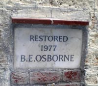
In 1926/7, the adjoining domestic buildings to the Tower were erected and the whole assumed a residential role. A flat roof with castellated parapet replaced the tank and William Adams was the first owner. His daughter married Harry Muirfield Braid, son of the famous golfer James Braid who lived at Earlsferry, Walton Heath. Harry was born in 1901, the year that his father first won the British Open Golf Championship at Muirfield. Harry and his wife lived at Tower House between the wars and his father would have been a regular visitor, probably accounting for why so many old golf balls are found in the grounds. During the second war years the house was let to Mrs Dorothy Morton and husband, who purchased the freehold in 1947. 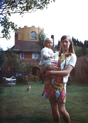 This author purchased the property in 1970 from the Mortons who retired to Worthing after building a substantial reputation as manufacturers and purveyors of hand crafted quality garden ornaments.
Picture: The Tower House in the early 1970s with Pat and Zelanie Osborne and Tiger the cat.
Building Works
One of the problems with the reuse of industrial buildings is that they were not built as residences. The result is that insulation is often poor, damp penetrates the walls and layouts can be awkward and inconvenient for modern living. In spite of this the challenge of an unusual building is one that the adventurous readily rise to and the skill is being able to develop a home from what was once a functional building.
Unfortunately the Tower House by the late 1960s was suffering from a further problem, one of neglect. There started in 1970 therefore a prolonged period of renovation and improvement necessary to ensure the continued use as a residence.
War Time Rumours - WW II
During World War II Canadian soldiers were billeted on the heath at Walton, pending the Normandy invasion. In fact the whole area was a hive of military activitiy. A German couple were arrested at Bells Cottage, Withybed Corner, following the noting of lights flashing in the sky during an air raid. Apparently a radio and signalling equipment were found. There were also rumours that German sympathisers were resident in Tower Road. Lights were seen signalling from the top of the tower at Tower House. The rumour appears to have come to nothing.
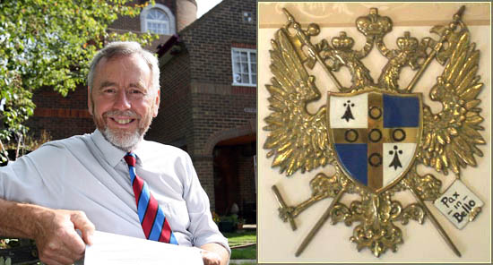
Bruce at Tower House - Osborne Arms "Quarterly, argent and azure, on a cross Or, five annulets sable, in the 1st and 4th quarters an ermine spot".
On the gable of the portico there is a coat of arms, just visible top right in the picture of Bruce above. This is of the Osborne family and is of great antiquity. The arms were used by the Osbornes of Newtimber in Sussex. Monuments in Newtimber Church and research indicate that this Osborne armorial lineage was in turn derived from the Osbornes of Hartlip in Kent where a substantial chapel exists with many monuments to this family. Both of these lines are extinct, however the Newtimber and Tower House lineage have a common root with a John Osborne of Poynings (1520 - 1597); the senior line being that of Tower House Osbornes. Another ancient branch of the Osborne family using the similar armorial is the Duke of Leeds lineage. This line became extinct in 1964 having originated in Ashford, Kent, where it can be traced from the 15th century. The hereditary dukedom perpetuates however. The commonality of the armorial indicates that all branches originate in medieval times from a common root of which the Tower House Osbornes are the senior inheritors.
SUPPLEMENTARY INFORMATION
Map: (Click to View in New Window)
1) TOPOGRAPHICAL LOCATION:
England
2) LANDSCAPE:
Rural Village3) INFORMATION CATEGORY:
Industrial ArchaeologyHistory & Heritage
5) GENERAL VISITOR INFORMATION:
Access By RoadOn Private Property
Not Open To Public