| 
|


The Hay Well
NGR 77518 45718
Site Number: C111
By Bruce Osborne and Cora Weaver (C) 2012
Area 1. Malvern Town Centre Springs and Wells
Malvern Hills, England
The derivation of this name is probably the same as Hay (or Hey) Slad, `hey' being the ancient name given to an enclosure made from a heath or forest. An engraving c.1820, reproduced in Jordan[1], shows the Hay Well pool in a clearing at the edge of the village of Malvern; the area is lightly wooded, a remnant of the village's days as a Royal Forest. The Hay Well is situated in the area formerly known as Southfield, which was almost certainly a vast open field formed by clearing a tract of forest.
The Hay Well was originally on part of the land that once belonged to Malvern's Benedictine priory. Chapter 66 of The Rule of St Benedict (c.480-547) instructed that, 'The monastery should, if possible, be so constructed that within it all necessities, such as water, mill and garden are contained.' Malvern's monks chose wisely, supplying their 11th-century priory with an inexhaustible source of spring water from the Hay Well. Pipes laid between the well and the priory were unearthed in the 1880s. The earliest known reference to a well in Malvern, in 1282, concerns some disputes over the lands belonging to the priory, when Bishop Giffard excommunicated two villagers, Stephen de la Wellputte (well pit) and Cecily atte Well. It has been suggested that these people had something to do with St Ann's Well, but, given the involvement of the Church, it is more likely that they had a connection with the Hay Well.
Another possible mention of the Hay Well was in 1540 when a well, known as `Powke putte,' was known to be located in South Field[2] ; the Southfields were originally a semi-marsh. Certainly it was the Hay Well which supplied the Priory during its conventual days[3] as pipes lying directly between the well and the Priory were unearthed in the 1880s.[4] The Hay Well also fed a pool in the subprior's orchard.[5] The pool, situated just below the present Baptist Church, was filled in at the end of the 19th century and now forms the garden of the property known as Salisbury, formerly Fonthill.[6] At the same time the inlet from the Hay Well was piped to an interceptor tank and then into a drain.[7]
Another possibility is that `Hay Well' is a distortion of `Eye Well' then the new found, eye-disease curing well mentioned in Bannister's 1622 breviary of eye diseases (see Eye Well) could very well refer to this well, and not to the Eye Well situated above the Holy Well.
 In a 1919 lecture entitled Malvern Past and Present, Dr Henry Jacob talked briefly about the monastic lands. He said that close to the upper border of the former monastic enclosure was the 'Hay Well' or 'Well by the Hedge'. Historically a 'hay' was a hedged enclosure made from a heath or forest into which animals were chased before being captured. Perhaps in this case the spring had been enclosed in a well and the well had been protected with a hedge to stop wandering animals from polluting it, which might easily have been done.
 The priory closed in 1539 and the monastic lands were bought in 1545 by wealthy John Knotsford. When he died in 1589 the estate passed to his wife's family, the Savages of Cheshire, until 1774 when alderman James Oliver of Worcester bought most of the estate. There was one small, enclosed piece of land of less than an acre that he did not buy. It was held in trust by Lord Thomas Foley of Witley Court on behalf of the daughter of the late Col. Savage. Eventually, in August 1777, Lord Foley sold the land, which was called Well Hay, to James Oliver for a massive �820. The land was bounded on the west by the turnpike road; on the north and east by a piece of land called The Walks, and on the south by a cherry orchard owned by James Oliver.
In the early 1830s George Warwick bought a piece of land on the north side of the Well-Hay and in 1833 opened a high class draper's shop. In the early 1840s he built some hydropathic baths on the east side of his land and named them after the nearest, most significant landscape feature - the Hay Well Baths. Soon after in October 1847 Charles Warwick bought the Well Hay itself and the surrounding public gardens. The site measured 51ft 4in along the Ledbury Road, 77ft down the 'public footpath' [Haywell Walk], 41ft along Abbey Road, and 63ft 6in on the north side, adjacent to his draper's shop.
The Water Flow - Details of the flow of water show it to be generally plenteous: Smith in "A History of Malvern" (1964) describes the flow to the Priory as inexhaustible; Edwin Lees in "Pictures of Nature around the Malvern Hills"[8] notes that the Hay Well is a very copious spring, now enclosed[9], probably a reference to the large dome with which it was covered during the 18th century when it was part of the Oliver Mason estates; May [10] describes the Hay Well as a privately owned, important and prolific source always flowing at 50 degrees. This observation probably came from Lamb who noted the constant temperature c.1845. Apparently in the winter of 1837/8, on 20 January the thermometer stood at 8 degrees below freezing near the well but when put into the water immediately rose to 50 degrees.[11]
By the early 1840s the Well was supplemented with water from the Green Valley; after feeding various buildings in the vicinity of Belle Vue Terrace, including the Unicorn, Mount Pleasant, the Library and the Foley Arms, the overflow ran into the Hay Well and down to Spa Mill, just above Pool Brook. Spa Mill was also supplied by streams from Miss Garlick's at Melton House and the North Firs. However, shortage of water caused the mill to close in 1844.[12] During the water shortages of the 1850s it was suggested that water should be taken from the Hay Well for watering the streets[13] but no further mention is made of this idea since Mrs. Warwick, below whose shop it lay, did not have the consent of the Trustees for the water to be taken and could not give it herself. In the mid-1860s the engineer Edward Wilson was asked to plan a new, reliable water supply for the town. He proposed using the Hay Well water in his scheme but never succeeded in gauging the flow of water because of the variableness in quantity in the space of just one hour.[14]
Naturalist Edwin Lees was a prominent member of Malvern Naturalist Club, which was founded in 1853. On one of their regular perambulation c.1854-5 they came upon 'A very fine copious spring, now enclosed, and called the Hay Well... ' [15] and added that the well was level with the ground. This suggests that what had once been a free-flowing spring had been enclosed in a brick-built well., but was only the first stage of a bigger scheme.
Shortly after this visit the site was enhanced when formal gardens were built around the well. Its spring water, which was available to the public, was extensively used by early-morning covens of hydropathic patients. One of Dr Wilson's patients recalled his first visit to the well in 1857. It was six o'clock in the morning as he set off clutching his Grafenberg glass. '... at the end of a little walk, hid away under some wet-haired willows, is the Hay-well, the most abundant of the many springs that come oozing and bubbling out from the bowels of the Malvern Hills. It is a round basin, some five or six feet deep, and about the circumference of a cart-wheel... I found a circle of patients already standing round the spring, all at work - the young and old, the fair and the brave - filling themselves like so many water casks. I lifted my hat to the moist company, one of whom had a tin saucepan, with a long handle... with which he baled from the well into the glasses of the water drinkers. "Shall I help you, Sir?" said he, poking the saucepan politely towards me. I held out my Graffenberg and it was instantly filled. I noticed that they all drank slowly - sipped or sucked in the element as though it were "Twenty Port," and they wished to make every delicious drop of it touch the palate before passing down.' [16]
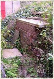
A late 19th century plan of the area shows that the Hay Well supplied several older properties to the east including Abbey Fold, three houses in Abbey Terrace, and the Abbey Hotel, which until October 1900 advertised itself as 'plentifully supplied with Soft Water from the celebrated Hay Well'. An 1884 advertisement for the Tudor House Hotel describes it as having hot and cold water laid on to every room 'from the world-celebrated Hay Well',[17] and from April 1903 the hotel's own advertisement mentioned that among its qualities was that 'The water, so celebrated for its purity, is pumped direct from the Hay Wells.' The Hay Well may also have fed the immersion bath at the new Baptist Church that opened in 1894 on a site immediately south of the Hay Well Baths. Henry Hilliard, a sanitary inspector during the 1920s, noted that a number of tanks associated with the Hay Well supplied older houses in the vicinity.[18] Until the 1930s the Hay Well was briefly described in Ward Lock's guides as one of the most abundant of the Malvern springs but today all that can be seen is the cistern into which the pipe runs before the water flows to waste.[19]
Illustrations:
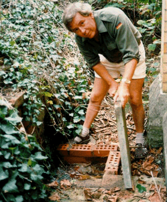
1. Discovering the Hay Well waters.
2. Listen for the sound of running water to identify the whereabouts of this site.
Footnotes:
[1] Jordan 1987.
[2] Smith p.171.
[3] Richardson p.118.
[4] May 1880s p.141.
[5] Smith p.87.
[6] Jordan 1987 p.17 & 21.
[7] Jordan 1987 p.21.
[8] Lees E 1856 "Pictures of Nature around the Malvern Hills" p.103.
[9] Richardson p.116.
[10] May 1882 p.141.
[11] Lamb c.1845 p.28.
[12] Malvern Advertiser 27 February 1864.
[13] Malvern Advertiser 9 August 1856.
[14] Malvern Advertiser 22 Nov.1873.
[15] Edwin Lees, Pictures of Nature (1856) p104.
[16] Leech, Joseph, Three Weeks in Wet Sheets (1858), p.86-7.
[17] Malvern Advertiser, 1 November 1884
[18] Richardson p.118.
[19] Ward Lock's guides 6th ed.p.36.
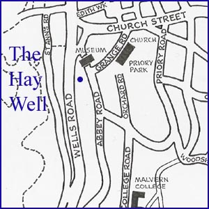
The map alongside is a small section of our more comprehensive map of the area. For the complete map together with a description and history of this site see "Celebrated Springs of the Malvern Hills" (2012).
Website: Click Here
SUPPLEMENTARY INFORMATION

Celebrated Springs of
THE MALVERN HILLS
 A definitive work that is the culmination of 20 years researching the springs and wells of the Malvern Hills, published by Phillimore. This is the ideal explorers guide enabling the reader to discover the location and often the astounding and long forgotten history of over 130 celebrated springs and wells sites around the Malvern Hills. The book is hard back with dust cover, large quarto size with lavish illustrations and extended text. Celebrated Springs contains about 200 illustrations and well researched text over a similar number of pages, together with seven area maps to guide the explorer to the locations around the Malvern Hills. It also includes details on the long history of bottling water in the Malvern Hills.
Written by Bruce Osborne and Cora Weaver, this book is available on-line for £15.00 (delivered UK) - click Malvern Bookshop on the green panel top left. Alternatively send a cheque payable to Cora Weaver with your name and address to 4 Hall Green, Malvern, Worcs. WR14 3QX.
1) TOPOGRAPHICAL LOCATION:
Malvern Hills - arguably Britain's original National Park
2) LANDSCAPE:
Built Up Location3) INFORMATION CATEGORY:
A Spring, Spout, Fountain or Holy Well Site4) MALVERN SPRING OR WELL SITE DETAILS:
Site with Malvern Water3 SPLASHES - Of Moderate Interest

5) GENERAL VISITOR INFORMATION:
Access On FootAccessible All Year