| 
|


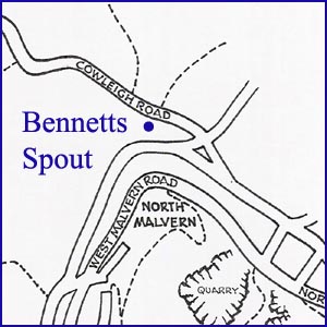
Bennetts Spout
NGR 76620 47507
Site Number: C24
By Bruce Osborne and Cora Weaver (C) 2012
Area 3. North Malvern Springs and Wells
Malvern Hills, England
Description: a block-built spout niche now dry
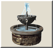
This spout is a modern construction and was used for commercial purposes. It lies in what is now the public car park for the Earl Beauchamps Fountain. The water source is similar to that of Earl Beauchamps Fountain.
In the past a new service reservoir was planned for installation between Old Hollow and Cowleigh Road, to the rear of the fountain. Unfortunately the ground slipped, the project was abandoned and the ground reinstated. After this incident the flow at the spouts diminished considerably.
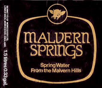
Circa 1982 Bennetts Dairies of Lower Wick reached an agreement with the Madresfield Trust to bottle water from the local spring for distribution on their milk rounds. A drainage system installed behind the spout collected water from five springs on the hillside. The water was then piped to the overground tank/reservoir in what is now the car park, from where it was transported by tanker to the bottling plant at the dairy at Lower Wick. The reservoir at the spout was yielding as much as 3,000 gallons per day and about 500 gallons per week were bottled. The bottling enterprise soon proved to be uneconomical, which was not helped when the spout went dry during the droughts of the late 1980s. A further complication was the introduction of two European Directives 80/777/EEC 80/778/EEC. Addressing the bottling of spring water, the Directives eventually became law in 1985 and placed legislative restrictions on conveying water for bottling.[1] The bottling project was abandoned.
Illustrations:
1. 1.5 litre label of 1989.
Footnotes:
[1] Official Journal of the European Communities, 30 August 1980, L229, Vol.23.
There is a good illustration of the spout in the book detailed below.
Website: Click Here
SUPPLEMENTARY INFORMATION

Celebrated Springs of
THE MALVERN HILLS
 A definitive work that is the culmination of 20 years researching the springs and wells of the Malvern Hills, published by Phillimore. This is the ideal explorers guide enabling the reader to discover the location and often the astounding and long forgotten history of over 130 celebrated springs and wells sites around the Malvern Hills. The book is hard back with dust cover, large quarto size with lavish illustrations and extended text. Celebrated Springs contains about 200 illustrations and well researched text over a similar number of pages, together with seven area maps to guide the explorer to the locations around the Malvern Hills. It also includes details on the long history of bottling water in the Malvern Hills.
Written by Bruce Osborne and Cora Weaver, this book is available on-line for £15.00 (delivered UK) - click Malvern Bookshop on the green panel top left. Alternatively send a cheque payable to Cora Weaver with your name and address to 4 Hall Green, Malvern, Worcs. WR14 3QX.
1) TOPOGRAPHICAL LOCATION:
Malvern Hills - arguably Britain's original National Park
2) LANDSCAPE:
Rolling Countryside3) INFORMATION CATEGORY:
A Spring, Spout, Fountain or Holy Well Site4) MALVERN SPRING OR WELL SITE DETAILS:
2 SPLASHES - Not Much To See
5) GENERAL VISITOR INFORMATION:
Access By RoadAccess On Foot
Free Parking Nearby
Accessible All Year