
| 
|

In the further investigation of what makes the Sussex Downs a special place and how it should be delineated for this study, existing delineations, including governmental administrative boundaries, are now considered. These have been selected particularly for their role in furthering area characteristics relevant to tourism, especially the distinct typography. They are also important in that they provide the foundation for the future designation and management regime of the region.
1. County and District Councils.
County Councils and District Councils, working under the statutory powers of planning and the Wildlife and Countryside Act 1981, have been instrumental in implementing a range of measures to improve public utilisation of the countryside generally. In addition, planning policies expressed in Structure Plans have been an important part of controlling land use and changes to the built environment. Policies for tourism and recreation are encapsulated in planning objectives and strategies and the unification of such policies is an important consideration within the proposed study. The difficulty is that Counties, which are administrative boundaries, intersect rather than conform to the obvious natural boundaries. Furthermore, Counties need aggregating to encompass substantial parts of the Downland, but in so doing include large tracts of Wealden dissimilar landscape. The implications of administrative boundaries are covered in the following text where relevant but Counties and their sub divisions are not considered a satisfactory means of delineating the study area. This view is expected to prevail with any forthcoming local government reorganisation, Sussex being unlikely to change from its existing two tier format.[1]
2. The South East.
"By whatever criteria it is studied or in whatever period viewed, the peninsula of South East England formed by the Thames and English Channel ranks as one of the world's most important regions. It's strategic position between London, the largest population mass in England and its seat of government, wealth and patronage, and the Continental mainland has ever made it one of England's advanced economies"[2]
The South East has much to commend it as a region which justifies being treated as an autonomous unit for an analysis of tourism. From the inception of Brighton as one of the first mass tourism resorts in the U.K. and the advent of cross channel steam packets to Dieppe from Brighton Chain pier, the South East has played an important role in tourism development.[3] This tradition of development is set to continue with forecasts for the Channel Tunnel traffic by the year 2003 estimated at 19.1 millions using the shuttle and 24.9 millions of rail passengers. Estimates for freight traffic are additional.[4]
However Brandon and Short point out that there is extreme regional diversity. This emanates from the geological configuration of the region and has led to "the gradual evolution of many different local landscapes and economies shaped by people of once rather different backgrounds, dialects and folklore, and developed at different rates and in different ways."[5] But not only is there great diversity within the South East, this diversity is seen as being greater than similar size areas generally.
As a result the South East England Tourist Board takes the view that the South East does not have a clear regional identity. Instead, components within the South East, ie. London, and the North and South Downs do provide distinct identifiable sectors giving a coherence to the whole.[6]
It can be concluded that in spite of a general progression to a monotony of landscape and culture and loss of local individuality as the region accommodates the ever pervading twentieth century styles and values, the South East does retain havens of distinct localised characteristics. These are inextricably linked with the heritage of the locality and as such are important factors in the value of a locality for recreation and leisure. The South Downs are environmentally and culturally significantly different for example to stockbroker Surrey, although each lies on chalk lands.
The diversity of the South East therefore prompts a rejection of this total region as a realistic area for detailed evaluation of tourism and instead a sub division of the whole is seen as more pertinent. This does not render it unworthy of consideration in the contest of a more autonomous sub division. The fortunes of tourism are closely linked to catchment zones as well as competition for "product" resource supply and the South East has a vital part to play in the prosperity of a particular sub division.
3. The Area of Outstanding Natural Beauty. (AONB)
The Sussex Downs AONB was designated on 22 June 1965 and confirmed the following year.[7]
AONBs were created as a result of the National Parks and Access to the Countryside Act 1949. This followed over half a century of lobbying for conservation and access to the countryside culminating in the Dower Report 1945, which set out management provisions under an autonomous authority.[8] This was succeeded by the Hobhouse Committee and Report in 1947 which advocated that twelve areas covering 9,500 sq. km. be designated as National Parks under a National Parks Commission. These areas included the South Downs although this was not implemented. In addition there were a series of conservation areas recommended.[9] In the same year Huxley reported on measures for wildlife and habitat protection.[10] The outcome was that the 1949 Act provided for two tiers of designation, National Parks and AONBs, each eventually to come under the Countryside Commission's remit as a result of the Countryside Act 1968.[11]
The principal aim of the AONB is "to conserve and enhance the natural beauty of the landscape." Two secondary aims, over which the principal aim takes priority, are to meet the need for quiet enjoyment of the countryside and to have regard for the interests of those who live and work there. This is effected by planning controls, practical countryside management, through local partnership and informed public support.[12]
Fig. 2:1 - The Sussex Downs
Area of Outstanding Natural Beauty.[16]
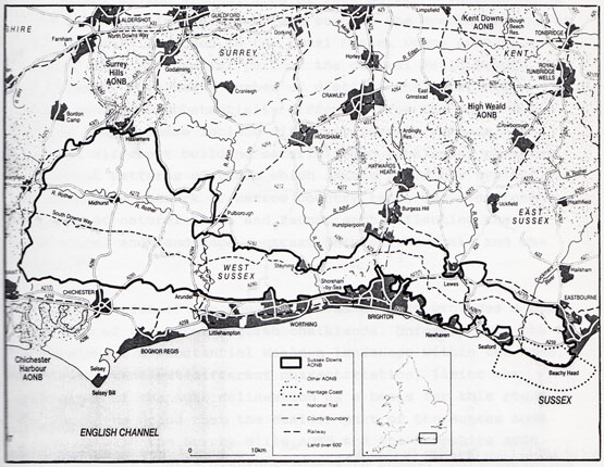
AONBs, covered thirteen percent of England and Wales in 1989.[17] Included in this total is the Sussex Downs AONB measuring 983 sq.km. which adjoins the East Hampshire AONB of 383 sq.km. giving a total area of 1366 sq.km.[18] This compares with a medium size National Park such as the Brecon Beacons at 1351 sq.km.[19] Included in the total Sussex Downs AONB area however is a substantial part of the central Weald beyond the chalklands. This has a number of distinct characteristics which render it substantially different from the chalk hills of the Downs. These include different farming methods and styles, different building materials and settlement patterns, different patterns of roads which in the Weald are typically an intricate network of narrow country lanes and a different profile of natural flora and fauna, each reflecting the geological and landscape contrast between the Weald and the Downs.[20]
The delineation of the South Downs as an AONB provides a sub division of the total English chalklands. Unfortunately the inclusion of a substantial Wealden landscape within the AONB, with important but different characteristics, limits the relevance of the AONB delineation as a basis for this study. It should be noted that the Wealden part of the Sussex AONB links up with the Surrey Hills AONB and the Hampshire AONB. This suggests that a distinct zone with common characteristics is encompassed outside the chalk Downland and this potentially provides a separate autonomous region.
The creation of the Sussex Downs Conservation Board in 1992 was an important management innovation for an AONB. This organisation provides a management focus for the Sussex Downs AONB region and is seen as a means of strengthening AONB status. Various countryside management responsibilities have been transferred from local authorities and exceptional additional funding of 50 percent of all expenditure secured from the Countryside Commission. West and East Sussex provide the balance funding at 30 and 20 percent respectively. A further important input comes from agencies which actively support selected aspects of the Boards work with direct finance eg MAFF through the ESA scheme.
In the first year of operation the Board assumed responsibility for 30 countryside sites in West Sussex as well as key sites in East Sussex including the Seven Sisters Country Park.[21] The Board has a six year mandate as a result of agreements with its 13 local authorities and is a pioneering experiment in the management of AONBs, however, it is without statutory powers. The strength of the Board over AONB management elsewhere being in its executive powers supported by a sizeable budget.[22] After the first full year of operation the Board had a staff of 29 and an annual expenditure of just over UK pounds 1.25m. The Countryside Commission component of this expenditure represents 35 percent of all Countryside Commission funding for AONBs and the largest allotment for any one AONB.[23] The aims of the Board replicate those of AONBs.[24] The administrative boundaries of the Board, being identical to those of the AONB, are an important consideration in determining the study area. Further discussion regarding the Board is given in Chapter 14.
A recent important development for AONBs in general is the Smart/Anderson Review Panel Report of 1990.[25] This in turn has solicited a Policy Statement from the Countryside Commission.[26] The longer term implications of these documents for AONBs and the South Downs are considered in Chapter 14.
4. Proposed National Park.
As has been noted earlier the South Downs are being actively promoted as a candidate for National Park status.
Like AONBs the National Parks were a product of the National Parks and Access to the Countryside Act, 1949. Initially under the remit of the National Parks Commission, responsibility for National Parks became that of the Countryside Commission after the 1968 Countryside Act.[27]
The aims of a National Park, encapsulated in the Countryside Commission's definition of such[28], are four fold;
a) to preserve the characteristic landscape,
b) to provide access and facilities for public open air enjoyment,
c) to protect wildlife, significant buildings and places of architectural and historic interest,
while....
d) established farming use is effectively maintained.
Like AONBs, National Parks are not owned by the nation. Land ownership is similar to areas outside designated areas. Administration is by local boards or committees of County Councils. One third of the board comprises members appointed by Government Ministers. The role of the board, in pursuing the policies of the National Parks, is one of liaison and management of resources within the parks. This is substantially assisted by central government funding up to 75% of running costs. In 1989 this amounted to UK pounds 18.5m.[29] Various local anomalies exist with National Park Authorities, such as their role as Planning Authorities and their full status as National Parks as in the case of the Broads.
Unlike AONBs, National Parks have a responsibility to promote public access and enjoyment. As well as promoting tourism, the board's activities include landscape conservation measures and the encouragement of appropriate small scale commercial development. Similarly, inappropriate large scale development is resisted.[30]
A support organisation exists for National Parks. The Council for National Parks is a national voluntary organisation comprising more than 40 member organisations. It acts as a watchdog on National Park matters. In addition there are facilities for individuals through the "Friends of National Parks" administered by the Council.[31]
Prior to the anticipated designation of the New Forest, the eleventh National Park, the total area covered by National Parks was 13,500 sq.km. This represents 9% of England and Wales.[32]
Although the Hobhouse report of 1947 advocates the designation of the South Downs as a National Park, this recommendation was not implemented for two reasons. a) National Parks were perceived as wilderness tracts and thus principally upland regions. b) The Downs had been substantially altered by extensive agriculture in World War II.[33] As agriculture was the prime land user, public access would present pressures on the farming community. The Downs were, much later, eventually designated as an AONB. The 1949 Act also specified regard to the distance to centres of population as a factor in determining National Park status. This alone provides some present day justification for the South Downs as a National Park but when linked with the "preservation of characteristic landscape" aim, makes a strong case for designation, particularly as eighty percent of traditional Downland turf overall has now been lost.[34] The campaign for National Park status has continued over a prolonged period. In 1990 the Council for National Parks published "A Vision for National Parks" in which the South Downs was one of four new Parks proposed.
Subsequent experience has cast doubts on the robustness of the AONB designation, in the light of social and economic pressures and development in the region and elsewhere, as has been previously noted under AONBs. This has prompted a further concerted campaign to secure National Park status for the South Downs, the core rationale for this being:
a) The need to recognise and conserve the heritage, wildlife, culture and landscape of the Downs, which is believed to be of National importance.
b) The need to recognise and develop the recreational facility of the Downs.
c) The need for stronger statutory planning powers and unified policy and management control.
d) The need for permanent additional funding to secure the Downs.
A South Downs Campaign Group has been created to further the objective.[35]
Fig.2:2. Proposed South Downs National Park.[37]
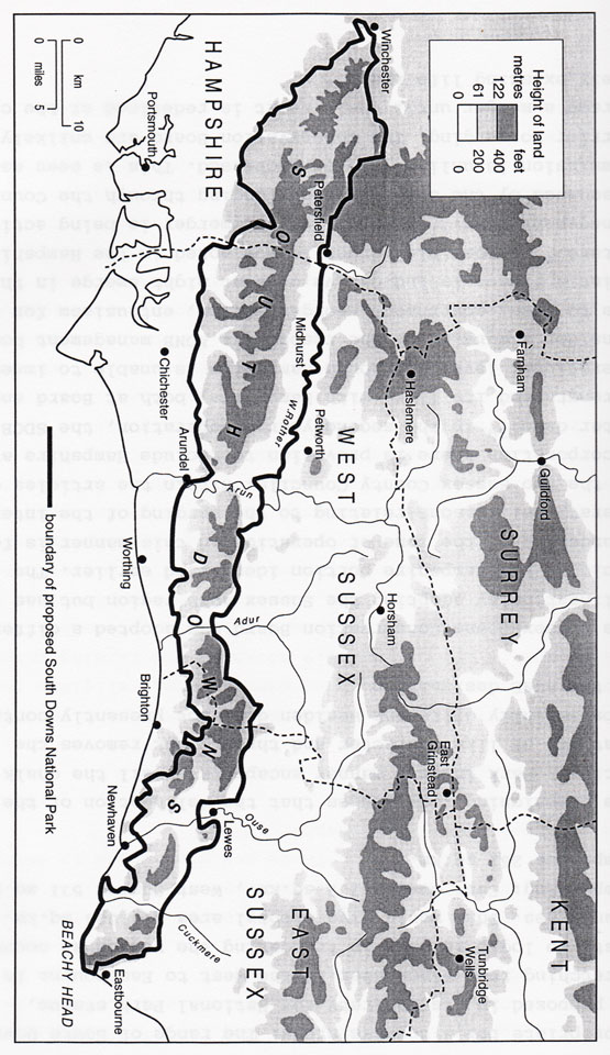
The proposed region for the South Downs National Park is significant in the context of the establishment of a region appropriate for a tourism study. The range of South Down Hills is proposed in its entirety for National Park status, stretching from Winchester in the west to Eastbourne in the east. No logic is seen in truncating the region at county boundaries. This would give a total area of 1024 sq.km. comprising: East Sussex 232 sq.km., West Sussex 531 sq.km., Hampshire 261 sq.km.[38]
The campaigning body argues that the delineation of the National Park in this manner encapsulates all the chalk lands that are of like character and threat, but removes the substantially different Wealden district presently contained in the AONB designation.
The Sussex Downs Conservation Board has adopted a different delineation by adopting the Sussex AONB region but has excluded the Hampshire portion identified earlier. The truncating of the zone of operation in this manner is for operational reasons relating to the merging of the interests of the two Sussex County Councils. Within the articles of incorporation there is provision to include Hampshire at a later date.[39] In the second year of operation, the SDCB has strengthened its links with Hampshire, both at Board and operational level. Although Hampshire is unable to immediately consider a merging of the respective AONB management bodies due to local government reorganisation, enthusiasm for the joint approach is indicative of what might emerge in the future.[40] A possible merger is now noted in the Hampshire Management Plan.[41] In addition the merger is being actively discussed by the SDCB although funding through the Countryside Commission is unlikely to be increased. This is seen as a barrier to merging. The Conservation Board are unlikely to pursue a merger until their remit is redefined at the close of their existing life span.[42]
An important development has been the possibility of new legislation for National Parks. This results from the Edwards Review Panel, which reported in 1991 and the Countryside Commission position statement of Aug 1992.[43][44] The implications for National Parks overall and possibly the South Downs are discussed in Chapter 14.
The adoption of the proposed South Downs National Park region as the basis of the region to be assessed in this tourism study has distinct merits. These are considered in detail in the conclusions to this chapter.
5. Environmentally Sensitive Area.(ESA)
This is a Ministry of Agriculture, Fisheries and Food (MAFF) designation which establishes certain areas eligible for assistance in environmentally advantageous farming practices. The assistance applies only to farmers and as such is potentially a valuable tool for landscape conservation and enhancement. ESAs were introduced in 1987 as a result of Section 18 of the 1986 Agriculture Act, arguably in response to concern that MAFF incentives for yield enhancement and crop specialisation were acting against the public interests for conservation. This at a time when food surpluses were embarrassing the CAP. The EC had previously issued a promulgation in 1985 which led to the 1986 Act. Article 19 of Council Regulations (EEC) no. 797/85 sets out to improve the efficiency of agriculture structures.[45] The relevance to tourism and outdoor leisure will be immediately apparent in a region where farming is the predominant land use.
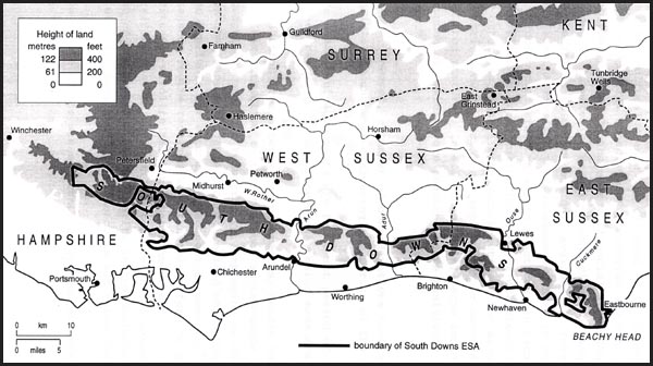
It can be seen in Fig. 2:3 that the area approximates to that proposed for the South Downs National Park. The South Downs ESA is 68,000 hectares in size, of which 46,000 hectares qualifies for the ESA incentives.[46]
The scheme is aimed at reducing damage and loss to wildlife and landscape and archaeological-historical preservation through agricultural change. In the case of the South Downs there is a specific objective of preserving and extending traditional pasture.[48] There is a financial incentive for the adoption, by farmers, of practices conducive to these aims. Participation is voluntary but only available to farmers in the ESA area. A five/ten year management scheme is entered into, binding the farmer to agreed practices, in return for finance aimed at ameliorating the loss of efficiency that would otherwise prevail with such practices. For example there are restrictions on fertiliser application or conversion to arable from pastural. In all cases walls, barns and other environmental features are required to be positively managed.[49]
There are, however, a number of considerations that need to be taken into account when evaluating the merits of the scheme.
a) The management agreements are for a set period of time and thus need renewing. If not renewed any gains made are lost.
b) Competition from alternative schemes may render the ESA option less attractive to farmers, such as set-aside which is now compulsory and more remunerative, impinging on what the farmer considers expendable productive land which could have become available for separate management agreements.[50] The maintenance regime required unfortunately offers no major benefits for wildlife habitat establishment and diversification. In addition the requirement to manage at the height of the breeding season results in the decimation of what wildlife does take up residence in set aside land.
c) New uptake of the scheme dramatically reduces after three years.[51]
d) In the South Downs ESA the total uptake in the first four years of the scheme was 6048 hectares (60.48 sq.km).[52] This represents only 6% of the proposed area of the South Downs National Park which the ESA approximates to. The scheme thus has only limited impact. Such low impact is typical of many Farm incentive schemes for conservation. Ilbery reports a disappointing uptake in the Farm Woodland Scheme introduced shortly after the ESA. In the first three years of operation the uptake was only that budgeted for the first year alone. Ilbery concludes that the attitudes and motives of farmers lie at the root of the failure to be enthusiastic about conservation schemes. Clearly much work needs to be done on this subject.[53]
e) The ESA scheme excludes public/recreational access arrangements under the Stewardship scheme; there is however a top up arrangement from the Countryside Commission for provision of public access. Public access incentives are the least taken up[54] and when in operation often have little benefits due to lack of public awareness.
f) By 1990, only 20% of the ESA take up had been used to restore traditional Downland sheep pasture and this may be threatened by set aside which does not permit grazing.[55] A further threat to sheep pasture reinstatement is the Sheep Extensification scheme. This is an EC measure to reduce sheep numbers by 20 percent. Heralded as a valuable measure for National Parks, the scheme may prove detrimental to the South Downs.[56] An encouraging feature of the Downland ESA scheme is that MAFF in 1993 indicated that grassland conversion had reached 5,000 hectares. When added to the pre existing 5,000 hectares of grassland, this gives a total of 10,000 hectares, approximately 10 percent of the proposed National Park area.[57]
g) Permanent chalk grassland is being ploughed as a result of alternative agricultural mechanisms competing with the ESA incentives. In particular oil-seed rape and linseed have proved disastrous to the vision of the Downs as promoted by such agencies as the Sussex Wildlife Trust.[58]
h) Frequent changes to the rules and incentives to farmers are resulting in farmers being unable to plan their businesses long term. This in turn means that other agencies are also being confronted with a confused and ever changing situation regarding land use and conservation.[59]
i) Long term set aside and associated measures, now introduced in recognition of removing land on a permanent basis from agricultural production, will have far reaching environmental effects.[60] This overshadows ESA provisions and is an issue considered in ensuing chapters.
It is now generally recognised that agri-industry can no longer be relied upon to be a conservator of the landscape or wildlife.[61] This view is endorsed by the Prince of Wales who comments on the work of the Game Conservancy on monitoring agricultural practices on the Downland, identifying pesticides and dimethoate in particular.[62] Shoard, in the classic work Theft of the Countryside (1980) goes further. She sees agriculture in the throes of another revolution. The first was the discovery in Neolithic times that the same piece of land could grow crops more than once if left fallow between cultivation. The further revolution was the restructuring of agriculture and the demise of the common grazing with enclosure between 1750 and 1850. Now we are experiencing a technological revolution the roots of which lie in the drive for home produced food in World War ll. As a result Shoard sees the traditional agricultural landscape as under sentence of death with the farmer as the executioner.[63] The belated introduction of ESA schemes in the late 1980s, resulting from public pressure created by such protagonists as Shoard still leaves the farmer holding the executioners axe. The traditional landscape is an inconvenient obstruction to the agri-industrialist.
Whilst the ESA scheme is of necessity one of the principal mechanisms for the conservation movement and of great potential importance in conserving the landscape and traditional Downland farming practices, its impact and duration is limited as a means of developing attributes of value to tourism. ESA schemes have not appeased many of the environmental pressure groups either.[64] The Council for the Protection of National Parks is particularly critical of the ESA scheme in the context of the South Downs, stressing underfunding as one of the principal limitations.[65] Such views are echoed by the Sussex branch of the Country Landowners Association, who indicate that farmers cannot afford to enter into ESA agreements at present rates of compensation.[66]
A working party for the Sussex Wildlife Trust reported on the effectiveness of the ESA in October 1990. The report concluded that the ESA should be continued but put forward twelve further recommendations to improve its effectiveness. The recommendations include a three tier system for chalk grassland protection, conservation plans, redrawing of the ESA boundaries and longer running projects.[67]
More recently the Sussex Wildlife Trust has produced a detailed report on the conservation of wildlife on the Downs. This sets out detailed proposals for the further development of the ESA which the Trust clearly sees as the principal instrument for integrating the demands of agriculture with those of the nature conservationist. Top priority is proposed for the old species chalk grassland and heath. This is argued as important for wildlife, landscape, cultural and recreational reasons. In addition the continuing importance of arable crops needs to be recognised and further efforts made to enhance wildlife under such regimes.[68]
The development of the ESA scheme is an evolutionary process and the emergence of a revised tailor made scheme for the Downland has great attraction. The conflict between set aside and ESA objectives was due to be addressed in the Autumn of 1993. Changes would include long term set aside and a Meadowland Scheme incorporating public access provision.[69] The Minister of Agriculture confirmed details of the proposals when opening the RSPB Pulborough Brooks Reserve in August 1993. These included payments for public access within ESAs, a habitat scheme involving taking land out of production for 20 years and a new aid scheme which will encourage organic farming.[70]
An important factor in coordinating the activities of MAFF with other agencies is the Liaison Group which meets from time to time. Represented on the group are a number of agencies with vested interests including the County Council, SDCB, English Nature and the Countryside Commission. The Farming and Wildlife Advisory Group (FWAG) is active in providing advice to farmers and landowners in Sussex on conservation work. This voluntary organisation, which is represented on the Liaison Group, is the only body whose sole role is to provide advice on farm nature conservation and wildlife habitats. As such its programme of direct consultation, training, demonstration sites and education provides a valuable further dimension to the MAFF ESA.[71]
Further support for the ESA comes from LEAF. Linking Environment and Farming is an initiative which seeks to introduce a system known as integrated crop management into farming practice. With the responsible use of production inputs it is demonstrated that consistent high economic yields are attainable but without the generally associated environmental degradation or health risks. Applesham Farm, which is located on the Downland near Lancing, is one of a number of demonstration farms in England. Leaf is financed initially by the European Crop Protection Industry but after 1994 will be self financing through subscription. Management is through a committee of representatives of key agencies with vested interests which includes MAFF.[72] Expansion of the scheme in the future has considerable potential for substantially enhancing farmland conservation on the Downs.
Such unification of effort will do nothing but strengthen the effectiveness of all concerned. The similarity between the ESA region and the proposed South Downs National Park is potentially valuable but only if a more effective scheme could be devised.
The ESA therefore provides a potentially important basis for the delineation of the landscape, as well as a means of keeping farmers farming on the Downland.
Discussion and Conclusion:
At this stage there appears to be a number of arguments in favour of adopting a region for this study similar to the proposed South Downs National Park but excluding Hampshire. In addition, a peripheral zone of tourism impact needs to be considered as part of a service facility for Downland Tourism. The proposal therefore is to adopt the Sussex Downland as the core zone with two peripheral zones, one north and one south as service regions.
The northern peripheral zone includes the Sussex AONB region not included in the core zone and is therefore not a homogeneous area. This will need to be accommodated in any considerations relating to the northern service region. Where possible, the northern boundary follows parish boundaries but this delineation is somewhat speculative. It will be seen that in some instances the County boundaries are used.
The southern peripheral zone includes the south coast seaside resorts but avoids the region south of Chichester and west to Portsmouth. This is seen as a distinct and different tourism region based on marine interest and heritage.
Fig.2:4. The Sussex Downs Tourism Study Region.
1) The region is a unified distinct range of chalk hills.
2) The character of the landscape, heritage, flora and fauna etc. is similar throughout.
3) It is similar to the MAFF. ESA., which was based on a single autonomous farming region. Only the Hampshire AONB chalklands are excluded.
4) A distinct climatic zone.
5) Reduces County Councils administrative regions to two.
6) Avoids the Wealden AONB in the core area.
7) Accommodates the dormitory potential and other tourism infrastructure and potential of surrounding districts.
8) The core area has a distinct, autonomous heritage, culture and history.
9) The core area lies totally within the remit area of the Sussex Downs Conservation Board. Recent division of the AONB into four management areas by the SDCB, results in the core study area being synonymous with the Western, Central and Eastern areas.[73]
10) The region including the peripheral zone falls entirely within the remit of the South East of England Tourist Board.
11) It accommodates the recommendations in the University of Edinburgh 1981 study, proposing the examination of tourism over a wider region in order to achieve objectives relating to the core area.[74]
12) Brandon identifies six natural regions of Sussex in his evaluation of the Sussex landscape. The core region corresponds to Brandon's South Downs.[75] Other authors have adopted comparable delineations in the past, Darby for example deals with the Downland as a distinct region.[76]
Negating the arguments for the adoption of the Sussex Downs as the core study area are three considerations:
1) The core area does not conform to any single existing region.
2) There is doubt as to whether more extensive or alternative chalk lands should be considered, possible the chalklands falling within the Hampshire AONB. This view is endorsed by Williams, 1993, who sees the South Downs in its entirety as a discrete ecological and geographical unit.[77]
3) Tourism data available from established sources is viewed and analysed by region, ie South East England, or by County.
In spite of these counter arguments the adoption of the Sussex Downs as the homogeneous core study area is the most appropriate course. Any other option precipitates substantially stronger arguments to the contrary. This area represents a land mass of 76,300 ha. which with the north and south peripheral areas makes up a total land mass of 286,000ha.
Footnotes:
[1] Monoghan S. 1994, "People Power Prevails" West Sussex Gazette, 22 Dec. p1.
[2] Brandon P & Short B. 1990, The South East from AD 1000. Longman, London. p1.
[3] Osborne B E. 1992, Brighton's Past on Shifting Sands? A Reinvestigation into the Transition from Spa to Seaside Tourism using Brighton as a Case Study, unpublished postgraduate dissertation, University of Birmingham, Chapter 6, p6 & p10/11.
[4] Eurotunnel, 1992, Interim Report. p8.
[5] Brandon P & Short B. 1990, p1.
[6] SEETB, 1991, South East First, A stategy for tourism in South East England, p7.
[7] Blunden J & Curry N. 1990, A Peoples Charter, Countryside Commission, HMSO. p162.
[8] Robinson G M. 1990, Conflict and Change in the Countryside, Belhaven Press, London. p316.
[9] Blunden J & Curry N. 1985, The Changing Countryside, Open University/Countryside Commission, Helm, London. p129.
[10] Blunden J & Curry N. 1985, p126.
[11] Blunden J & Curry N. 1985, p135.
[12] Countryside Commission, 1989, Areas of Outstanding Natural Beauty in England and Wales, CCP276. Cheltenham.
[13] Osborne B E. 1991, The Rural Impact of Mineral Water Bottling Enterprises, research report prepared for British Natural Mineral Waters Association based on unpublished dissertation, Worcester College, p39.
[14] Haines G H. 1973, Whose Countryside? Dent, London, p42.
[15] Phillips D & Williams A. 1985, Rural Britain, A Social Geography. Blackwell, Oxford. p161.
[16] Countryside Commission, 1992, CCP 379.
[17] Countryside Commission. 1989, CCP 276.
[18] Countryside Commission, 1992, Directory of AONBs, CCP 379.
[19] Countryside Commission, 1992, Protected Landscapes in the United Kingdom, CCP362, Manchester, p9.
[20] Phil Belden, (former) Conservation Project Officer, West Sussex County Council, personal communication, 22/10/92.
[21] Sussex Downs Conservation Board, 1993, Annual Report, 1992/3, p5.
[22] Sussex Downs Conservation Board, 1994, Minutes of Executive Committee, item 47, 8 Dec.
[23] Lloyd R. 1995, personal communication, Countryside Commission, 13 June.
[24] Sussex Downs Conservation Board, 1994, Annual Report 1993/4.
[25] Smart G & Anderson M. 1990, Planning and Management of Areas of Outstanding Natural Beauty, Countryside Commission 1990, CCP 295.
[26] Countryside Commission, 1991, Areas of Outstanding Natural Beauty, a policy statement, CCP 356.
[27] Countryside Commission, 1989, National Parks in England and Wales, CCP 208, Cheltenham.
[28] Countryside Commission, 1992, CCP362, p5.
[29] Countryside Commission, 1989, CCP 208, Cheltenham.
[30] Countryside Commission, 1989, CCP 208, Cheltenham.
[31] Countryside Commission, 1989, CCP 208, Cheltenham.
[32] HM Government, 1990, This Common Inheritance, Britains Environmental Strategy. p105.
[33] Blunden J & Curry N. 1990, p101.
[34] Shoard M. 1989, "Parks with a Difference", The Times, 27 March.
[35] South Downs Campaign, 1990, A Draft Outline for a New Style South Downs (National Park) Authority, Campaign document September.
[36] South Downs Campaign, 1990, p3 item H.
[37] South Downs Campaign, 1990.
[38] South Downs Campaign, 1990, p4.
[39] Sussex Downs Conservation Board, 1991, Revised Agreement. Nov, 7(2)(i).
[40] Sussex Downs Conservation Board, 1993, "Report by the Clerk and Sussex Downs Officer - East Hampshire AONB", Board Meeting Agenda, 22 Oct, item 17.
[41] P Tiplady, Sussex Downs Officer, 1994, personal communication.
[42] SDCB, 1995, discussion, at meeting held on 23 Jan.
[43] Edwards, R. 1991, Fit For The Future, Report of the National Parks Review Panel, Countryside Commission CCP 334.
[44] Countryside Commission, 1992, Action for National Parks, position statement, CCP 394.
[45] Countryside Commission, 1992, Protected Landscapes in the UK, CCP 362, p46.
[46] MAFF. 1993, personal communication with regional office at Lewes.
[47] MAFF. 1993.
[48] Willis K G. Garrod G D, & Saunders C M. 1993, Valuation of the South Downs and Somerset Levels and Moors ESA Landscapes by the General Public, University of Newcastle, Centre for Rural Economy, Executive Summary, p3 & 7.
[49] MAFF. 1991, Conservation and Diversification Grants for Farmers, PB0537. p3-4.
[50] Phil Belden, (former) Conservation Project Officer, West Sussex County Council, personal communication, 22/10/92.
[51] MAFF, 1991, The South Downs, ESA monitoring report, p3.
[52] MAFF, 1991, table 1:1.
[53] Illbery B & Kidd J (Coventry University), 1992, "Adoption of the Farm Woodland Scheme in England", Geography, Volume 77/4. p363.
[54] P Tiplady, Sussex Downs Officer, 1994, personal communication.
[55] Phil Belden, (former) Conservation Project Officer, West Sussex County Council, personal communication, 22/10/92.
[56] Friends of National Parks, 1992, "Sheep Extensification", Viewpoint, p3.
[57] MAFF. 1993, personal communication with regional office Lewes.
[58] Williams R. 1993, AVision for the South Downs, Sussex Wildlife Trust, May, p35.
[59] Monaghan S. 1993, "Farmers Suffer through Hotch Potch Plannning", West Sussex Gazette, 12 Aug. p1.
[60] MAFF Land Use Planning Unit, 1994, Agriculture and the Rural Economy, Sussex Downs AONB, Reading, August, see 3:5, 3:10, 3:26.
[61] Tourism & Recreation Unit, University of Edinburgh, 1981, National Parks, A Study of Rural Economies, Countryside Commission, CCP 144.p53.
[62] HRH Prince of Wales, 1991, "Why We Must Manage the Land, The Field, April, p63.
[63] Shoard M. 1980, The Theft of the Countryside, Temple Smith, London, p8 & 13.
[64] Blunden J & Curry N. 1990, p265.
[65] Hunt N. 1993, New National Parks The Next Steps, Council for the Protection of National Parks, 2.21.
[66] Homer P. 1993, "Killer Weed Invades our Countryside", West Sussex Gazette, 2 Dec., p1.
[67] Working Party of Sussex Wildlife Trust, 1990, South Downs ESA Report, edited by Rendel Williams.
[68] Williams R. 1993.
[69] Norris G. 1993, "Incentives for Management", presentation at the Sussex Chalk Grassland seminar, Weald and Downland Museum, 14 July.
[70] Monaghan S. 1993, "Friendly Farming Package", West Sussex Gazette, 12 August.
[71] Whelon D. 1990, Report of the Sussex Farm Conservation Adviser, Sussex Farming and Wildlife Advisory Group.
[72] LEAF, c.1991, Linking Environment and Farming, data packs available at the demonstration farm launch 20 May 1993. Coordinators: National Agricultural Centre, Stoneleigh.
[73] SDCB, 1994, four published maps of the management areas.
[74] Tourism & Recreation Unit, University of Edinburgh, 1981, p51 & 75; See also Chapter 4.
[75] Brandon P. 1977, The Sussex Landscape, 2nd.ed. Hodder & Stourton, London. p31.
[76] Darby B. 1975, View of Sussex, R Hale & Co., London, see contents.