
| 
|

What are the Sussex Downs? This thesis opens with a detailed examination of what makes the Downland a distinct place and how it can be delineated for the purposes of this research. This preliminary, yet extensive, data gathering has been necessary because of the absence of any comprehensive landscape inventory of the Downland, a matter which the Sussex Downs Conservation Board (SDCB) considers a major problem but which is now being addressed by the Countryside Commission.[1]
The first two chapters consider the rationale for the most appropriate delineation of the proposed study region. In so doing they consider the dominant characteristics of the region as well as highlighting a number of problems of delineation. The evaluation of the dominant characteristics in turn identifies what makes the study region a special place for the visitor - the visitor invocation. This is carried out in the context of local distinctiveness and sense of place growing in political importance and becoming a focus of inherent planning conflict.[2] Chapters 1 and 2 therefore perform a dual role, first they establish an argument for delineation and then, in so doing, identify the characteristics which render the study area different from elsewhere.
The Sussex Downs are a part of the South Downs which in turn are part of the South of England chalklands. In addition the South Downs are also part of the distinctive geology of the Wealden District. Physical geography is not the only consideration. The Sussex Downs are part of the once prosperous South East which in turn is part of the southern section of the well established north/south divide. Economics therefore has a place in determining the study region. There are administrative/planning boundaries, the most apparent being the County boundaries and more recently the Sussex Downs Conservation Board operational areas. A further element relevant to this study are the key tourism resources, their nature and dispersion and their relationship with adjoining regions. At the root of many of these considerations lies the physical geography. This in turn substantially affects the natural as well as man made environments.[3]
The first consideration in determining the study region relates to whether the study is of a typical sample evaluation that in turn can be argued to represent the whole or is this research a comprehensive area study. The Downland study is not seen as being illustrative of circumstances on a larger scale. Instead it is an examination of a distinct area in its entirety. The study area therefore will be a definable homogeneous territory encompassing a zone of distinctiveness. Part regions and boundaries not relevant to that distinctiveness are of less interest.
What then are the realistic boundaries of the region to be studied? Matthews discusses the difficulties in arriving at recognisable regions and lists twelve varying definitions, concluding that there is no universal agreement on what makes a region. Using statistical technique, Matthews proposes the Kruskal-Wallis non-parametric test to give a "H" statistical measure of difference between ranked samples.[4] In the case of the Downland, the identification and ranking of precise quantified factors presents problems in selection and quantification. Matthews also suggests formal planning regions; this approach has limitations for a Downland study which will necessarily be centered about an environmental region not encompassed by the established County, District or other administrative boundaries. From the academic debate it can be maintained that it is an individual's perception that is crucial in determining what is a region, an approach argued by Claval.[5]
Whilst the modern academic debate has a value in enhancing our understanding of regionality, it is the 19th century geographers who provide the clues for developing a rationale for delineating the Downland. Mackinder's ideas, first expressed in 1887, included the notion that the smaller an area the greater tends to be the uniformity within.[6] Although any sub division is a component part of the greater region, no matter how the sub division is arrived at, so there will be further diversity within that sub division. In recognising this problem it can be seen that within a region the common characteristics provide regional identity, whereas diversity within highlights comparisons of local peculiarities.[7] This leads to the notion that, when considering topography, a region is an area containing greater diversity without than within. Administrative boundaries, as will be shown in Chapter 2, do not necessarily accord with topographical boundaries and this mismatch is an issue addressed in the delineation debate. A further factor is whether tourism provides a basis for delineating a study region. Its nebulous nature, complicated by the multiplier effect, results in tourism's impacts being particularly difficult to define as will be demonstrated in Chapter 4.
In order to pursue a rationale and understanding for the defining of a study region, it is proposed to look at a number of topographical distinctions based on human and natural geography in this chapter. These are then compared in Chapters 2 and 3 with established delineations which are contrived by man. The contrived delineations are important because they often set out to perpetuate and enhance topographical differences over substantial areas. This, together with the nature of their remits, makes them especially relevant to tourism.
Topographical Delineations:
1. Chalklands.
Any study of the Downland, whether it be the Sussex Downland or further afield, must necessarily be based on the undulating chalk hills which typify the landscape.[8] Such landscape is associated with sheep farming and the predominant surface feature of the farmscape is the traditional grassland pasture. Due to changes in farming practice, remnants of this grassland now exist mainly on the steeper slopes which are unsuited to arable farming.[9] Shoard sees the chalk landscape as an environment that is particularly special to England, there being few counterparts elsewhere in the world. This aspect will be developed further in the detailed attributes of the region selected for study. As such the chalk Downland, the South Country, typifies the image and perception of rural England for many.[10] This idea is further developed by Brandon who notes the inspiration that the Downs have given to artists and writers, as well as providing a landscape with qualities of serenity, restfulness and homeliness.[11] The implications for a study of tourism are immediately apparent.
The Cretaceous chalk uplands were historically derived from white calcareous ooze laid down during the Cenomanian Transgression which affected England as well as mainland Europe.[12] Considerable variation occurs within the chalk but it is typified as a soft white friable limestone, consisting of over 95% calcium carbonate. The upper chalk is characterized by beds of flints.[13] This has given rise to distinctive building materials. Towards the end of the Cretaceous period the Alpine orogeny was heralded by the Wealden uplift. Subsequent erosion of the ensuing anticline produced the present day Wealden structure and physical geography.
The uplifted and subsequently eroded Wealden anticlinorium covered an area approximately 135 miles long and 50 miles wide, stretching from Bas Boulonnais in northern France through Kent, Sussex, Surrey to the Hampshire Downs.[14] Erosion has produced a ring of chalk hills, notably the North and South Downs, enclosing the exposure of the underlying older strata. Folding and faulting has resulted in localised anomalies and the incursion of the English Channel has divided the dome, severing the chalk perimeter at Dover and Beachy Head.
These geological processes have given rise to distinctive landscape features and amplitude of relief, which in turn differentiate the chalk Downland from elsewhere.[15] The striking chalk escarpments of the North and South Downs are the result of the continuing erosion of the underlying soft Gault clay by sub-aerial denudation. The Upper Greensand calcareous sandstone and the Chalk are more resistant to such processes and a steep slope results. Each escarpment is thus receding.[16]
Both the escarpments and the dip slopes of the Downs are intercepted by coombes. These dry valleys result from a combination of former spring erosion and periglacial processes.[17] As such they form a distinctive undulation in the topography which, in extreme circumstances such as the Devil's Dyke, have become tourist venues. The notable absence of surface drainage water is highlighted by Stamp who contrasts the chalklands with the Weald. "It shows very strikingly the absence of surface streams on the chalk of the South Downs".[18]
A further feature of the south-east chalk Downs are the river gaps. These cut the Downland into five upland masses, divided by the Cuckmere, Ouse, Adur and Arun.[19] The rivers originate from the radial drainage patterns established during the Wealden uplift. These have been superimposed on the subsequent landscape, possibly in conjunction with an intervening sub aerial relict planation with marine intervention as discussed by Woolridge.[20] Gallois notes that although superficially similar, each river valley has its own individual features.[21] Not only have these gaps provided communication routes through the Downs, they also provide distinct surface utilisation and, in the case of the Cuckmere Valley, important tourism attractions.
Since the Neolithic period there has been a rise in sea level and the subsequent partial drowning of land area has resulted in a range of distinctive coastal features. The more resistant chalk hills have given rise to cliffs where they now meet the sea. One of the most notable seascapes is the Seven Sisters, where the South Downs, eroded with a series of coombes east of the Cuckmere Valley, meet the sea in spectacular near vertical cliffs culminating in the 525ft high Beachy Head.
Fig. 1:1 Chalkland regions of England
(derived from Stamp's simplified geological map [24]).
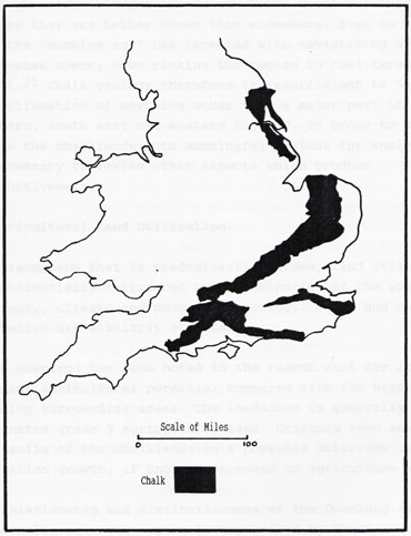
Massingham, in his classic work on the English Downland, was hard pressed to justify differentiation of the Sussex Downs from Downland elsewhere. In "honour and reputation", Massingham acknowledges the Sussex Downs excel but only because they are better known than elsewhere. Even so he notes that the "machine age" has impacted with devastating effect on the Sussex Downs, down ranking the region in real terms as a result.[25] Chalk geology therefore is insufficient to justify the delineation of anything other than a major part of southern, south east and eastern England. In order to sub-divide the chalklands into meaningful regions for analysis, it is necessary to review other aspects which produce distinctiveness.
2. Agricultural Land Utilisation.
In a landscape that is predominantly farmed, land utilisation is substantially influenced by a combination of the physical geography, climate and underlying geology. Soils and natural vegetation are similarly affected.
Chalk Downland has been noted in the recent past for its marginal agricultural potential compared with the higher yielding surrounding areas. The landscape is generally designated grade 3 agricultural land. Chisholm even saw the poor soils of the chalklands as a possible deterrent to population growth, if England depended on agriculture alone.[26]
The relationship and distinctiveness of the Downland as a discernable agrarian region is emphasised by Short in the review of south east rural society 1750-1945. Nine historic agrarian regions are identified throughout the south east of which region vii of Fig.45 suggests a convenient Sussex Downland delineation. In region vii Short identifies the traditional farming as being mixed sheep/grain and sheepwalks with beechwoods to the west in the eighteenth century.[27] The success of the Southdown sheep by the mid 19th century, supplemented by the activity of the rabbit, resulted in the establishment of an extensive close cropped turf. In the 20th century, the drive for wartime food production, new farm technology and the influence of the Common Agricultural Policy has brought about fundamental changes in the nature of Downland farming. The traditional landscape has given way to an agri-industry scape. There is now growing pressure from many commentators to recognise the belief that the farmer can not be relied upon to maintain the rural landscape in a manner that is aesthetically pleasing.
To the south of the South Downs, the coastal region comprises urban areas, interspersed in the west with arable lands bordering the coast from Worthing to Portsmouth. The substantial lowlands south of Chichester represent the major part of this type and as such form a distinctive division of the landscape. Underlying geology comprises Tertiary Beds overlain with Pleistocene and recent deposits and as such is significantly different from the Downland to the north.
Similarly the Weald is distinct and separate. Here a medley of alternative farming types results in a mottled landscape with a plethora of crops and husbandry. This ranges from hops, orchards and dairying to mixed farming, cattle fattening, forestry and uncultivated heathland.
Within the Downland there are distinct sub divisions.
Most of the Downland is upper chalk occasionally topped with clay with flints. The latter gives rise to a wooded landscape in the west, where Beech predominates, but which is less apparent in the east.[28] Most upper slopes of the Downland are designated medium quality land with shallow light soils. Extended sheep grazing, coupled with dunging off the Downs, has produced a nutrient deficient grassland which has become the traditional, characteristic vegetation.
The lower slopes of the Downland provide areas of good general purpose farm land. These are likely to be somewhat more sheltered and are opportunity for alternative farm uses such as vineyards. Where the slope is extreme however sheep grazing is the principal usage. Now most of the remaining traditional sheep pasture is in such locations. Modern farming methods have resulted in the easier slopes being turned over to cereals.
To the immediate north of the Downland, the Greensands and the Gault Clays provide a distinct boundary zone between the Weald and the Downs. This gives rise to grassland pastures which is also a characteristic of the downland north south valleys.
Extending up the north south valleys are the alluvium deposits. These provide a series of distinctive breaks in the Downland. The flat river flood plains and the underlying geology result in grazing land.
It can be seen that the region divides into a series of distinct agrarian areas:
a) The coastal area to the south of Chichester, from Worthing to Portsmouth.
b) The exposed chalk uplands with shallow light soils, in places topped with clay and flints.
c) Lower slopes of the Downland.
d) The perimeter zone to the north before the Weald proper.
e) The river valleys running north south.
However Stamp, Short et al have demonstrated that the Downland in turn forms one of three distinct agricultural zones of the South East: The Weald, The Downland and The Coastal Plain. This enables the Sussex Downland to be identified as a meaningful delineation albeit with variation within.[29]
3. Historic exploitation patterns.
The ebb and flow of man's occupation and exploitation of the Sussex Downs has resulted in a unique and rich reservoir of archaeology. Although man was present earlier, human impact was minimal and it was not until about 10,000 years ago that a warming of the climate resulted in nomadic hunters arriving from the east across what is now the Channel but which was then, probably intermittently, dry land. This post glacial hunter/gatherer culture located particularly along the southern shores bordering the South Downs.[30]
During the Neolithic period significant technological and cultural change took place in the south east. Farming, both pastoral and arable, impacted on the landscape with major forest clearance. It is generally accepted that the south east was largely wooded prior to this era.[31]
The Bronze Age heralded the spread of metal working technology from Europe. Drewitt et al identify the time from 3,000 - 1,400 BC as a period no longer dominated by a fortified settlement system. Spatial distribution of surviving archaeology indicates extensive use of the Downland between the Arun and Beachy Head.[32] After about 1,400 BC, archaeological evidence substantially improves and it is possible to identify how the Downland continued to be the important region for farmsteads.[33]
Five hundred years before the Roman conquest, the new technology of the day resulted in the onset of the Iron Age. Recent scholarly work now suggests that England was actually becoming overcrowded and therefore both the Weald and the Downs were extensively farmed prior to the Roman incursion, with marginal uplands being fully utilised.
The Roman invasion resulted in a significant development of infrastructure with a number of key sites being established. For example Chichester become a major regional centre. Great prosperity was achieved in the first and second centuries AD in Sussex. A road building programme was initiated. There was however a clear delineation of human geography. The Weald was primarily noted for its iron working and had an economy based on metalliferous industry. The principal Roman places of habitation continued to be on and in the vicinity of the Downland.[34] Temples and other masonry buildings, farmsteads and the walled town of Chichester characterised the South Downs and the coastal strip to the south.
During the third century AD, the gradual erosion of the mechanisms for the exchange of goods and taxation resulted in an economic decline. With the lessening of Roman influence, the Saxon landings started in the fifth century. The Downland became an important area of Saxon activity with the Weald being notably less attractive for habitation.[35] A substantial decrease in population suggests that there was a retreat from the more marginal lands other than for occasional common grazing. The Wealden forest regenerated.
This pattern of human geography was to last for many hundreds of years. It had the effect of preserving the complex pre-Saxon archaeology of the higher Downland from later agricultural disturbance.[36] By the time of the Norman conquest and Domesday survey, the southern half of Sussex held the vast majority of manors, in contrast to the inner Wealden region which was sparsely populated.[37] Much of the interior of the south east contained the then largest remaining area of woodland and heath in England. The Downland and coastal fringes were where human activity was focussed.[38]
The Norman period intensified the exploitation of the Weald. The Normans sought mobility through the Weald as their main route to mainland Europe. New settlements were established and the Weald became populated to a greater extent.[39] Dispersion of population was a feature of late medieval Sussex with the Weald maintaining an industrial economy. Thereafter settlements were more evenly distributed throughout the south east.
In the 17th and 18th centuries the gentry established Country Seats and Parks on the Downland. The process of enclosure ensued, perpetuated in the interests of greater agricultural efficiency as well as enabling large land holdings to be secured in private hands. During the 18th and 19th centuries the upland Downs underwent sheep intensification. An absence of ploughing enabled the archaeology to be further conserved, unlike the extensively ploughed lowlands and central Weald. On the Downland this trend has in recent years reversed under the influence of the Common Agricultural Policies of the EC. During and since World War ll, deep ploughing has destroyed much of the archaeology.
4. Cultural Boundaries.
The defining of cultural boundaries requires an appreciation of the customs, civilisation and heritage of the communities under scrutiny. The close relationship between culture and landscape means that each must be viewed in the context of the other. Such an evaluation is inevitably qualitative in nature and also temporal. In spite of this however, distinct bands of culture do exist in the south east. Within such bands, it can be argued that a certain distinctive culture and heritage can be related specifically to the Downland.
The interpretation of the factors making up culture however is in the eye of and dependant on the value systems of the beholder. The perception of the culture to an outsider is considerably different to that of the active participant. The visitor therefore has a different perception of the regional cultures than the host.
This difference in perception is important in determining the tourist product. Whereas the tourist seeks an idealised experience and easily consumed culture, by contrast the local populace are unable to be as superficial. Their culture is the real world in which they have to live and prosper. The depth of experience is therefore greater than that of the tourist. To the local populace, culture gives rise to the venting of class value systems, patronage of the arts, fashion and a whole host of behavioural traits that differentiate communities. This differentiation does emerge as an identifiable variation in the activities of mankind, but to the tourist it is a backcloth upon which impressions are superimposed relating to the tourism experience. Often, for the tourist, culture is a combination of heritage, nostalgia and marketed imagery. The tourist contemplating the wares of the street vendors in Brighton on a bank holiday, perceives the experience as an integral part of being in Brighton. There is little appreciation for the actual lifestyle and real circumstances that the street vendor experiences. Both live in different worlds that overlap on Brighton sea front.
For tourism, the perception of local culture as the outside world sees it is paramount.
The portrayal of the culture comes about in many ways. Cultural history and its communication conjures up images and nostalgic memories. Invariably these are out of context and arguably can never be fully appreciated by a person looking through present day eyes. Even the re-creation of history in specialist heritage venues provides an artificial insight. The re-enactment of bygone scenes can never capture fully the problems of a poor diet or of disease. Culture is also portrayed by marketing, in this case the communication of images and beliefs. The vehicles for this range from the spoken word, painting and music to every channel of the media, be it printed text or satellite TV. Everyday we are bombarded with messages that we collate into generalised impressions of place and people. It is in the evaluation of these messages that we can differentiate the cultural boundaries of the Downland and surrounding districts.
To the south of the Downland, the seaside resorts present a distinct culture of their own to the outside world. This suggests a confused assortment of Victorian seaside, historical heritage, big business and modern metropolis. The enormous success of the south coast resorts during Victorian times in attracting tourism has left a residual culture of seaside fun and frolics. It manifests itself in the built environment, the style of the seafront arcades, beaches and piers and the sexual undertones of the visitors' activities. The historical heritage becomes apparent with the commercial adoption of activities such as smuggling to provide visitor entertainment. ESCC note that "The 1066 heritage is a particular asset and marketing focus."[41] Big business is epitomised by the conferences and exhibitions that locate on the south coast - a world of expense account accommodation and high powered executives. All of this is wrapped up in the bustling activities and value systems of the culture of the modern townscape, congested with traffic, large retailing complexes, office blocks and all the accoutrements of a busy town centre that could be anywhere in England, if not in the world.
By contrast the Downland provides an alternative culture. This is particularly apparent from the extensive literary works associated with the region. Such authors as Kipling and Belloc encapsulated the character of the Downland in their writings.[42] Even the hard to please William Cobbet admired the Sussex Downs.[43] Subsequently their example has been followed by a plethora of authors. There are a wide variety of publications which seek to capture the intrinsic values and idyll of the Downland. Pyatt in Chalkways of South and South-East England particularly identifies the close relationship between the landscape and underlying geology.[44] The relationship between mankind and the landscape is narrated in works such as Meynell's Sussex written in 1947 and with many subsequent reprints. Chapter 9 in particular draws on the heritage of the Downland and in so doing creates a nostalgic idealised view of Sussex life.[45] Within the popular, rather than the academic literature, contenders for the most comprehensive description of the Downland imagery and idyll are profuse. In Darby's View of Sussex, Chapter 2 is devoted to the Downland and within this he covers all the key aspects of what goes to make the popular perception and image of the Sussex Downs, the flora and fauna, Downland villages in rolling hills, rural pursuits and skills and the distinctive buildings.[46] Hudson similarly devotes extensive text to such issues.[47] Beckett, writing in the early 20th century identified a "Spirit of the Downs", an indefinable presence with which the visitor can commune in solitude. To comprehend the gift that it brings is to find one of the joys of life.[48]
The detailing of recent history also provides a cultural nostalgia with which we can closely identify. Our grandparents knew these times. It is pertinent to who and what we are. This appeal comes across in Barclay Wills' Downland Shepherds.[49] In this book the character of the Downland is developed linking the social history of a sheep farming occupation with reminiscences of real people in an idyllic landscape, where hardship somehow enhances the appeal rather than detracts from the imagery. We are exposed to symbolism from which we extract what we feel comfortable with. The hardship is noted but not experienced from our comfortable, centrally heated lounges. The social and natural history provides comfort to us in a world that is otherwise full of strife and industrial pollution. These sentiments are worthy of conservation and experiencing first hand. Such a presentation is idealised, not only by the authors but by the recipient also.
Other publications encapsulate the Downland culture in photography and text, ranging from the factual guide to poetic romanticism. The availability of early postcards and the collections of archive negatives have promoted a fusion of nostalgia with culture, enabling the viewer to interpret the images as they wish. Guilmant in her book Sussex selects pictures of horse-drawn hay wains, an East Dean shepherd (Tom Breach of East Dean who clearly posed for this and a number of similar "contrived" pictures at the time [50]) and rolling hills to capture the spirit of this part of Sussex.[51] Using modern colour photography, Hollingsworth in 1981 shows rolling downland above Telscombe, Chanctonbury Ring atop rolling green pastures, Halnaker Mill with cattle grazing in the foreground, the seven turf topped hills and cliffs of the Seven Sisters, Alfriston, the show village, Hoddern Farm above Beachy Head, home of suspected smuggler John Osborn, who mysteriously disappeared in the 1850s[52], the landscape around the Long Man of Wilmington and the Beachy Head Cliffs.[53] These selected photographs capture idealised, tourist Sussex. They illustrate the culture as the visitor sees it of a historic farming community, rolling green hills with remnants of ancient earthworks, interspersed with small quaint villages where people indulge in rural crafts and customs in an idealised time warp, that is far removed from the reality of post industrial Britain.
Further north the Downland gives way to the Wealden landscape. Historically impenetrable and with an early economy based on the iron, glass and wood industries, the Weald conjures up images of a culture that, like the coastal resorts, is mixed and confused.
Towns such as Crawley, Horsham and Haywards Heath are urban centres that give only token recognition to the historic heritage of the region. Modern centres of commerce and industry are hard pressed to capture an image and culture that appeals to the tourist. Outside the towns, the farming community still reflects the patterns set down during the early clearing of the Wealden forest.[54] In spite of this, the varying nature of modern agriculture coupled with a variety of other land uses has resulted in the Weald presenting a hotch potch of culture and landscape. This amalgam has many facets and suffers from the compromise of a culture of modernity in conflict with a wish to encapsulate the stability and nostalgia of heritage. This aspect is summed up by Brandon and Short who see the rapid and unplanned urbanisation of the region dramatically affecting the way in which the landscape is perceived and enjoyed.[55] The picture painted is one of culture in turmoil with no particular focus.
The Economic Development Group of East Sussex County Council recognises this lack of clear definition as a problem generally in Sussex.[56] Only the Downland has a clearly defined cultural image in tourist terms. This makes the chalk rolling hills a distinct and valuable property for the tourism planner, a point considered in greater detail in the ensuing chapters. The cultural characteristics embody strong images of both a heritage landscape and people surrounded by regions of diverse cultures. In particular, modernity appears to have missed the Downland. The incursion of 20th century culture has occurred in the surrounding regions but has been thwarted by the rolling green hills. This has created an apparent timelessness that provides a valuable creative platform on which to build a tourism orientated economy.
5. Settlement distribution.
The landform of the Downs has given rise to pockets of settlement tucked into coombes and valleys where a patchwork of hamlets and villages stand in stark contrast to the bustling seaside resorts to the south and the industrialised towns to the north. Water supply has been a significant factor in establishing settlement distribution with an absence of surface water on the chalklands. This is ably illustrated by Stamp who identifies the substantial conurbations of the south coast. These are in turn contained by the belt of Downland to the north where settlement is occasional. Further north, this in turn gives way to the Weald with numerous tiny hamlets and villages interspersed with major towns.[57] Although prepared fifty years ago, Stamp's overall patterns still persist, giving the Downland a distinct characteristic. The intrusion of 20th century development, particularly housing estates, has marred this idyllic landscape, but in spite of this, much of the Downland, by and large, retains its traditional geography.
6. Tourism resources and catchment zones.
The detailed resources of tourism relating to the study area are considered in Chapter 4. At this stage the organisation and structure of tourism is investigated to ascertain its relevance to the delineation of a study region.
It is apparent that the south coast resorts provide a significant tourism attraction in the south east. Those resorts between Bognor and Eastbourne accommodate a coastal strip immediately adjacent to the Downland. Further east the Kent coast resorts spread from Bexhill to Herne Bay. Brighton is the largest of all the resorts and boasts at least five attractions, each processing in excess of 100,000 visitors per annum.[58]
Throughout the south east there is a considerable dispersion, with no discernable distinct pattern, of tourism attractions. These comprise a wide range of facilities including zoos, gardens, theme parks, historic properties, stately homes, castles, railways, caves etc. etc. Three hundred and fifteen such attractions are identified on the South East England Tourist Board 1:200,000 map. [59] Interspersed with the formal venues are a whole plethora of footpaths, commons and informal recreation facilities. The South Downs Way provides the focus of the network of footpaths and bridleways on the Downs.
There is little obvious pattern to tourism venues with the exception of:
a) The south coast resorts, which represent a distinct band of east west coastal locations on the southern border of the Downland.
b) The outdoor recreation facilities which particularly cluster around the eastern Downland at Beachy Head and at Goodwood in the west.
Tourism catchment areas similarly provide little assistance in the division of the south east into meaningful study regions. There is the immediately apparent resource of London and its urban areas. This is encircled by the M25 motorway. In addition, all of the towns in the region, together with the rural settlements, provide massive visitor potential for the south east. Again the dispersion does not lend itself to distinct divisions within the region.
The presence of entry ports for visitors from the continent means that tourists will fan out from those ports following the lines of communications. The pattern of visitors from Europe particularly is destined to alter considerably with the opening of the Channel Tunnel. This imposes an element of uncertainty into the future patterns of such visitors.
In view of the distribution of tourism resources, the diversity of catchment zones for home tourism and the uncertainty of future European visitor patterns, tourism has been dismissed as a factor to assist in the determination of the study area. The three qualifications that can be put on this however are:
1) The coastal strip south of the Downland incorporates significant seaside resorts. The vast underutilised dormitory facilities of the south coast resorts, together with their attendant recreation and visitor facilities, are a latent tourism service resource for the Downs
2) The entire south east comes under the remit of a single tourist board, The South East England Tourist Board (SEETB)[60]. This considerably eases the administrative problems of tourism on the Downland.
7. Climatic Zones.
The Downland in the south of England falls within a distinct band of climatic variation that differentiates the region from elsewhere. Three characteristics prevail along the southern Downland and Coastal strip which make the area particularly attractive to tourism. These are:
1) Below 175 days of rain per annum with only rare short duration, high magnitude events.
2) Above 4.5 hours of sunshine per day average.
3) More than 300 days with the average temperature in excess of 5.5 degrees C. (42 degrees F).
Most areas of the British Isles have less sunshine, lower average temperatures and more days with rain. No other chalk region can claim these three characteristics.[61] The National Rivers Authority considers their Southern Region to be considerably drier than England and Wales as a whole, with 790mm of rain per annum.[62]
Historically, climate has featured as a major health attraction to the area.[63] The fact that the South East enjoys some of the best weather in the UK is a point often not now appreciated.[64] This has led to some of the regions most important visitor attractions being "outdoor".[65] Climate is a primary influence in the topography of a region as has already been noted. Coupled with underlying geology, climate, particularly rainfall, leads to the determination of erosion and soil characteristics which in turn influence land form and utilisation.[66] The chalk geology of the Downland, coupled with the distinct climate, results in a unique combination of circumstances giving rise to a terrain and surface features unmatched elsewhere.
Within the Downland there is localised variation consequent from the undulating geography of the area. Not only is there the thermal contrast resulting from sunlight on north versus south facing slopes. There is also the relationship of the sheltered coombes and valleys to the more exposed hills which provide protected zones from the winds but renders the lower areas subject to greater frost risk.
8. Bio-diversity.
The Downland provides a unique environment for bio diversification, which makes it an important ecological region not reflected elsewhere in England. Many noteworthy species are at the most northern limits of their European distribution and minute environmental changes can cause major fluctuations in population sizes. All the wildlife habitats on the Downland are historically man made and it is the combination of natural and man made factors that results in the unusual and spectacular bio diversity. This diversity is reflected in both plants and animals.
The old chalk grasslands are the most notable of the wildlife habitats. These result from centuries of sheep and rabbit grazing and now manifest a natural appearance. One square meter can contain forty species of flowering plant, many of which are aromatic in the summer. It is one of the most intricately diverse plant communities in western Europe. Elevation and aspect result in diversity within the grasslands and those of the east are distinct and different from those in the west. The Downland is noted for orchid populations and the University of Sussex has a monitoring programme.[68] Many species are considered to have survived from the early Holocene, having found refuge on the sea cliffs when the hills were forested.
In tandem with the plant diversity is insect diversity. About sixty percent of all British butterflies can be found on the Downland. One particularly important species is the Adonis Blue, Lysandra bellargus. Now restricted to twenty five distinct colonies it is at its most northern limits of survival.
The ecosystems of the chalk grasslands are fragile in that they are based on nutrient and grazing patterns established through extended monoculture. Man's intervention either by diminishing grazing or adding fertilisers to expand yield disturbs the balance. As a result pasture developed over extended periods of time is permanently damaged. Ploughing has always been a threat to the grasslands, from the Napoleonic Wars to the latest World War the land has been ploughed to increase arable production. In recent times the WSCC estimates that between 1971 and 1981, 32 percent of the Downland turf was lost. The National Trust compute that a similar amount has been lost since 1981.[69] This level of loss has been confirmed in the recent findings of the English Nature/Countryside Commission/WSCC audit, which has shown that by 1991 only 3.4 percent of West Sussex land area comprised unimproved grasslands, a loss of 38 percent over 10 years.[70] Later estimates suggest that only 2,650 ha. of chalk grassland survive on the South Downs, representing a mere three percent of total chalk based surface area. Most of this is inevitably concentrated in the SSSIs.[71] Fragmented isolation of species does present particular problems for recolonisation and renders species more vulnerable to extinction threat, a subject now under detailed investigation by Thomas et al at the University of Birmingham.[72]
Other Downland habitats that are important include Juniper scrub, gorse thickets, chalk heath and chalk scrub. Each provides unique opportunities for wildlife diversification. For example, gorse thickets provide habitats for Dartford Warblers and the decline in gorse thicket has seen a corresponding decline in the Dartford Warbler.
Woodland is also an important aspect of Downland wildlife. In the East the plantations are relatively recent, the most notable being Friston Forest.
In the west the characteristics of woodland are different. Many woods were planted in the eighteenth and early nineteenth centuries by the great estates. They provided sources of timber as well as having significant landscape value. Here the principal trees are beech and ash.[73] In addition, protected areas of ancient woodland such as Pads Wood SSSI, where hazel predominates, and yew woodland at Kingly Vale, provide important habitats for varied flora and fauna.
The rich natural diversity of the Downland can be gauged from the register of SSSIs, details of which are given in Chapter 3. These not only reflect the quality of the natural environment but also the efforts being made to counteract man's relentless detrimental intrusion into the landscape. Even civil engineering works like roadbuilding however, have a benefit by providing new opportunities for colonisation by species. As such the Downland represents a distinct island of flora and fauna which, although not being singularly consistent throughout the Downs, does never the less provide a unique habitat zone.
Having reviewed the principal topographical characteristics as determinants of delineation based on distinctiveness, the following chapter looks at contrived delineations.
Footnotes:
[1] Landscape Design Associates, 1994, A Landscape Assessment of the Sussex Downs AONB, consultation draft, Oct.
[2] Clark G. Darrall J. Grove-White R. Macnaghten P. & Urry J. Lancaster University, 1994, Leisure Landscapes - Leisure, Culture and the English Countryside: Challenges and Conflicts, CPRE, May, 4.36-39.
[3] Darby B. 1975, View of Sussex, R Hale & Co., London. p16.
[4] Matthews J A. 1981, Quantitative and Statistical Approaches to Geography, Pergamon Press, Oxford, p118-122.
[5] Claval, quoted in Matthews 1981, p118.
[6] Gilbert E W. 1972, British Pioneers in Geography, David & Charles, Newton Abbot, p165.
[7] Cunliffe B & Hey D. 1990, see preface in Brandon P and Short B. The South East from AD 1000, Longman, London. p xiv - xv.
[8] Hawkins J M. 1987, The Oxford Reference Dictionary, Clarendon Press, Oxford. p244.
[9] Millmore P. 1990, South Downs Way, National Trail Guide, Countryside Commission/Ordnance Survey, Aurum Press. p19.
[10] Shoard M. 1990, The Case for a National Park, SRCC/CPRE Conference, University of Sussex, 9 Feb.
[11] Brandon P. 1990, The South Downs - a Very Special Place, Countryside Campaigner, Summer edition. p20.
also see: Whittow J. 1992, Geology and Scenery in Britain, Chapman and Hall, London, p57.
[12] Gallois R W. 1965, The Wealden District, British Regional Geography, 4th ed. H.M.S.O. p38.
[13] Gallois R W. 1965, p39/40.
[14] Gallois R W. 1965, p53.
[15] Williams R. 1993, A Vision of the South Downs, Sussex Wildlife Trust, May, p3.
[16] Gallois R W. 1965, p70.
[17] Gallois R W. 1965, p72. See also Whittow J. 1992, p59.
[18] Stamp L D. Briault E W H. & Henderson H C K. 1942, The Land of Britain, Sussex (East and West), Parts 83/84, Geographical Publications Ltd, London, p475,478/9.
[19] Darby B. 1975, p47.
[20] Wooldridge S W. 1965, "The Weald; geomorphology and sequent occupance" in Steers J A. 1965 ed. Field Studies of the British Isles, Nelson, London, ch 6, p82/3.
[21] Gallois R W. 1965, p74/75.
[22] Webster Smith B. 1945, The World in the Past, Ware & Co. London. See plate 83/84.
[23] Darby B. 1975, p41.
[24] Stamp L D. 1948, 3rd Edit. 1962, The Land of Britain, its use and misuse, Longmans, Green & Co. London, Fig 136.
[25] Massingham H J. 1936, 3rd Edit. 1949, English Downland, Batsford, London, p73.
[26] Chisholm G G. 1913 ed. Handbook of Commercial Geography, Longmans, Green & Co. London, p216. It is interesting to note that in post war editions, e.g. 14th ed. 1954 rewritten by Stamp, that the South Downs are no longer included in this consideration as war time measures increased agricultural production, see p321.
[27] Short B M. 1983, "The Changing Rural Society and Economy of Sussex 1750-1945", in University of Sussex Geog. Editorial Committee, 1983, Sussex: Environment, Landscape and Society, Alan Sutton, Gloucester, p148 -152.
[28] Darby B. 1975, p64.
[29] Stamp L D. et al. 1942, p 491 - 520; Short B M. 1983, p148 -152.
[30] Drewitt P. Rudling D. Gardiner M. 1988, The South East to AD 1000, Longman, London, p12.
[31] Drewitt P. et al. 1988, p24.
[32] Drewitt P. at al. 1988, p64.
[33] Drewitt P. et al. 1988, p88.
[34] Armstrong J R. 1978, A History of Sussex, Phillimore, Chichester, p28-33.
[35] Armstrong J R. 1978, p38/9.
[36] Taylor C. 1988, in revised edition Hoskins W G. 1955, The Making of the English Landscape, Hodder and Stourton, London, p17 & 40.
[37] Armstrong J R. 1978, p42, 52/3.
[38] Brandon P & Short B. 1990, The South East from AD 1000, Longman, London, p24.
[39] Armstrong J R. 1978, p56/7/8.
[40] Brandon P & Short B. 1990, p13.
[41] ESCC, 1992, ATourism Strategy for East Sussex, p19.
[42] Brandon P. 1977, The Sussex Landscape, Hodder & Stourton, London. p28.
[43] Darby B. 1975, p39.
[44] Pyatt E C. 1974, Chalkways of South and South-East England, David & Charles, Newton Abbot. appendices 1&2.
[45] Meynell E. 1947, Sussex, Robert Hale, London.
[46] Darby B. 1975, Ch.2.
[47] Hudson W H. 1901, Nature in Downland, Longmans, Green, and Co. London.
[48] Beckett A, 1930, 5th ed. The Spirit of the Downs, Methuen, London. p2.
[49] Payne S & Pailthorpe R, 1989, Barclay Wills' The Downland Shepherds, Alan Sutton, Gloucester.
[50] See: 1992, Tom Breach, Shepherd of East Dean, post card from Seven Sisters Country Park.
[51] Guilmant A. 1991, Sussex of 100 years ago, Alan Sutton, Stroud. p 59,84,112.
[52] Sussex Express, 1855, Extraordinary Treatment of an Enfant, Coroners Inquest reported 27 Jan. after which the parents "disappeared".
[53] Hollingsworth A and Bloomendal F A H. 1981, England in Cameracolour, Sussex. Ian Allen, London. p 30, 56-68.
[54] Brandon P & Short B. 1990, p3.
[55] Brandon P & Short B. 1990, p2/3.
[56] ESCC, 1992, p6
[57] Stamp L D. et al. 1942, p 521.
[58] BTA/ETB, 1992, Regional Tourism Facts South East England, CS974, SEETB, Tunbridge Wells, p9:3 - 9:8.
[59] South East England Tourist Board, undated circa 1991, 1:200,000 Map of South East England, Estate Publications.
[60] SEETB, 1991, South East First, A Strategy for Tourism in South East England, p2.
[61] Wrexford Watson J. 1968, Atlas Advanced, Collins Longman. p59.
[62] National Rivers Authority, 1990, Guardians of the Water Environment, Southern Region, Dec.
[63] Harwood W. 1828, Curative Influence of the South Coast of England, Colburn, London.
[64] ESCC, 1992, p20.
[65] WSCC 1986, Visitor Survey, Nov. p1.
[66] Wooldridge S W and Goldring F. 1966, The Weald, Collins, London, p106/7
[67] Potts A S. & Browne T J. 1983, "Climate of Sussex", in University of Sussex Geog. Editorial Committee, 1983, Sussex: Environment, Landscape and Society, Alan Sutton, Gloucester, Page 105/6.
[68] Monitoring programme by Hutchings M. School of Biological Sciences, University of Sussex.
[69] West Sussex Gazette, 1993, "Downs are on their Way Up", 4 Feb.p6.
[70] West Sussex Gazette, 1993, "Our Wildlife Havens are Facing Ruin", 4 March.
[71] Streeter D. 1993, Ecology of Chalk Grassland, presentation at Sussex Chalk Grassland seminar, Weald and Downland Museum, 14 July.
[72] University of Birmingham, 1994, "Can the Butterfly make a Comeback?" The Birmingham Magazine, Number 6, Sept. p28/9.

Click the book to return to the Title Page and Chapter List